Ash Road - Hoselands Hill
About the road

Hoselands Hill - Looking south from Bramblefield junction (L-R)
1908, 1926 and 2017
Hoselands Hill, the main entrance to Hartley from the north, is a name that is in danger of being lost, as it has been swallowed up into the greater Ash Road. It is a vital part of Hartley's infrastructure and chaos ensues if the road is blocked, because the only alternative routes north are via country lanes, and most traffic originating in Hartley is travelling north. But it makes sense in terms of this series of articles to break Ash Road up into more manageable chunks. Generally Hoselands Hill is taken to mean the length of Ash Road between the railway bridge and Wellfield.
The origin of the name is unclear. Once again there is the problem that there are no references to the name earlier than 1844. A lot of "hoe" placenames are derived from the Old English word "hoh" meaning heel. Our Hoselands does not quite fit the classic profile of such placenames, which is a concave slope to a summit which then gently falls away on the other side, like somebody's heel would look if they were lying on their stomach. However in many place a hoh placename may be given to any spur of land, which of course Hoselands is, as it lies between the Longfield and Fawkham valleys. Early 20th century accounts suggest a narrow lane carved through the chalk with beech trees meeting overhead to create a green tunnel.
Hoselands Hill was a beneficiary of the council's decision in 1907 to engage in public works to help the unemployed in the recession then. Local landowners were supportive, and donated land for widening. Mr Morton of Fairby (the tenant of Hottsfield) even supplied 17½ days of team labour free of charge. Up to 32 men at a time found work here. They widened the road and put down a new rolled flint surface. The photo shows the road was still narrow even after widening, so you wonder how narrow the road was before then! Hartley's rapid growth led to plans to widen the road again in 1924, Dartford RDC got a grant of £293 from the Ministry of Transport towards the £585 cost. The improvements also included kerbing, the addition of a footpath and sloping of the banks. The road was made up of best blue Guernsey Granite and surface tarred, large granite chips were used to prevent slipping. By 1938 the road had acquired white lines in the middle and then catseyes in 1946.
Further widening of the west side occurred in 1954. The Parish Council had concerns that the chalk bank was being eroded by frost and rain. Ancient beech trees had to be removed, but the county council planted new ones. The most recent widening occurred in 1968 when the railway bridge was replaced and a gentler curve added. This left a segment of the old road where people used to park to avoid car park charges, but in 1984 KCC put double yellow lines from the railway bridge up to Copse and also banned driving along the old section of road (I recall people used to park there for free). In recent years the traffic island near the Bramblefield junction and the path and dropped kerbs near the railway bridge have been added to help pedestrians. The latter was inserted to regularise an unofficial footpath.
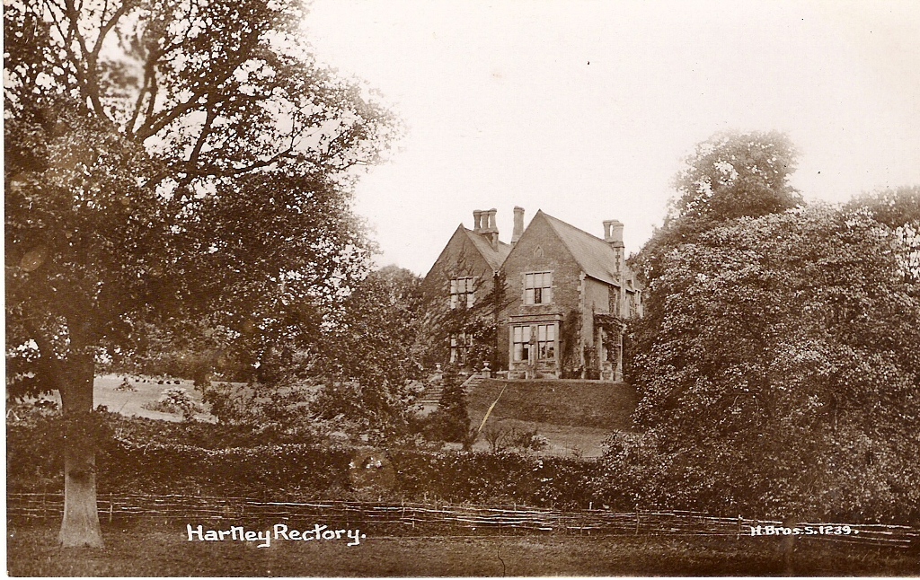
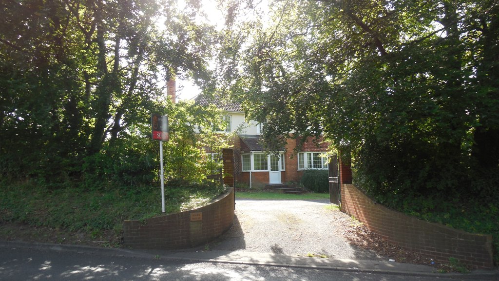
The Old Rectory, built 1851
Historically the area was sparsely settled, visitors to Hartley from Longfield would have to travel all the way to Woodins at the bottom of Church Road before they came to a house. And the only buildings in Longfield would have been the Court and Church. The centre of the village then was at Longfield Hill.
The first house built here was the Old Rectory in 1851. Reverend Allen lived at Wilmington before, but was ordered by the Bishop to live in his parish, so he built his parsonage at the nearest point to Wilmington to make it easier for his friends and family to visit! The remains of the house are in the woods there, but are dangerous due to hidden cellars.
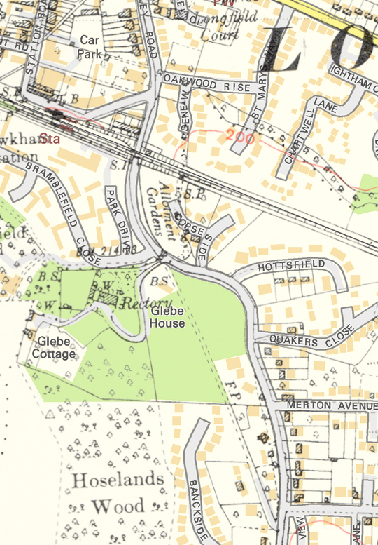
Hartley-Kent: Hoselands Hill 1936 map (houses black and hatched) overlaid on the modern map
(houses in brown)
Three more houses were added before the first world war - Grafton House (1906), Amberley (1913) and The Gables (1915). The first two were built on the Payne and Trapps Fawkham Park Estate. Most of the other houses on Ash Road were added in the 1920s and 1930s. After the war there has been infilling particularly around the unmade road opposite Hoselands Green.
Dartford Rural District Council bought 1 acre of land at the bottom of Hoselands Hill in 1921 with a view to build council houses there and they had accepted the quote of local builder William Braybrook of £4,872 to build 6 houses there. However the Local Housing Board vetoed the project as being too expensive. By 1935 the council had abandoned the idea to build here and had let the land out as allotments. Eventually the land became part of Copse Side.

Hoselands Hill by entrance to footpath, about 1920
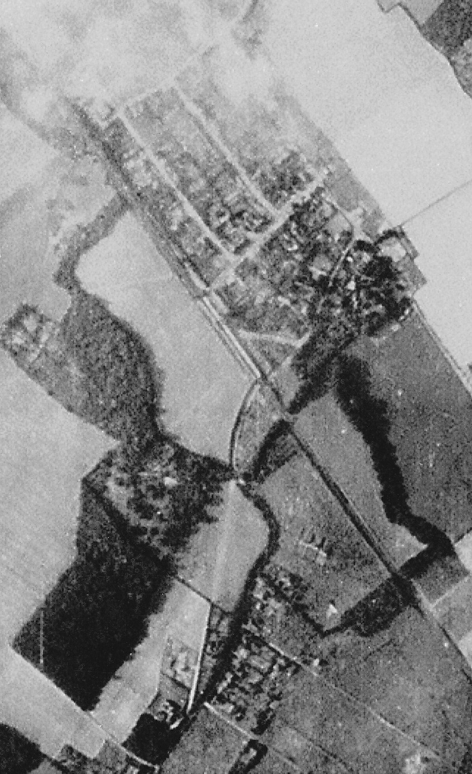
Aerial Photo of Hoselands Hill 1940, railway bridge is in centre,
Wellfield at the bottom of the picture
Statistics about the road
| Subject | Details |
|---|---|
| Length of Road: | Part of Ash Road (1.8 miles / 2.9km) |
| KCC Reference: | Part of C252 (Class C carriageway, adopted) |
| Acreage: | Part of urban Ash Road 28.43a (11.51 ha) |
|
Houses/Flats |
29 |
| Density: | Part of urba Ash Road 4.2 houses/acre (10.3 houses/ha) Hartley average 4.9 houses/acre |
| Population (2011): | 109 (excludes Tudor House, The Birches) |
Information about the houses
Explanation:
Date of Construction is sometimes approximate.
(1) Details of the type of house and the plot history. Plot histories include the ancient farms and fields with the earliest known date, also the
name of the smallholding sold by Smallowners Limited at the beginning of the 20th century.
(2) Planning Permissions include the reference number, so more details can be seen at Sevenoaks Council.
My records are not complete and I have not included refused or withdrawn applications.
(3) Before Council Tax the tax on residential property was called the rates. The registers for 1956, 1963 and 1972 are
held at Sevenoaks Council. The rateable value given is the gross estimated rental value of the property, that is how much
the Valuation Office thought people would pay to rent it, the rates were actually calculated on a lower value after certain
statutory allowances were made. For some reason the 1956 register contains the rateable value for the properties as it would
have been in 1939.
(4) Council tax is based on what the Valuation Office thought the property would have sold for in 1993. It is divided into 8 value bands.
(5) House price data 1995 to date produced by Land Registry © Crown copyright 2016. To report
an error, go to Change a sales record form.
I have tried to make sure the information is accurate, but no responsibility can be taken for any errors. If you plan to rely on the information, you should check the source data to be sure. If you spot an error, please let me know via the contact form.

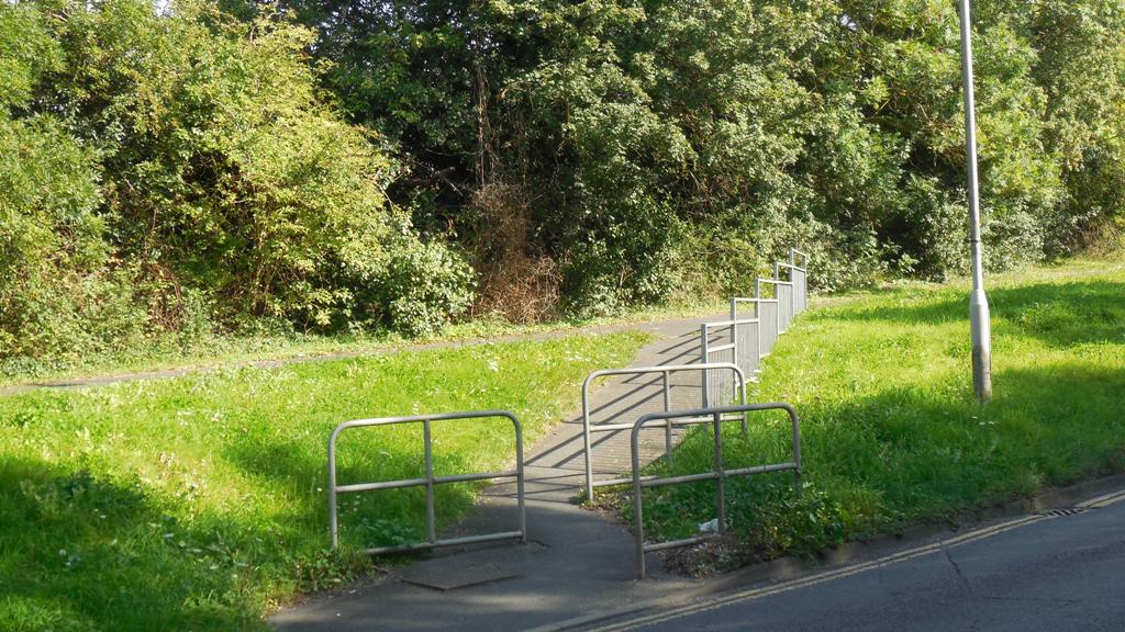
Railway Bridge and Path by bridge
Copse Side, Ash Road, DA3 7DY
Built: 1924
Demolished: 1965
(1) Property Type: Detached
(1) Plot History: Hottsfield (1656)
(2) Planning Permission: 1924/Meeting 1924-07-15 Brick Bungalow (application says "Hartley Hill")
(3) Rateable Value (1956): £40
(3) Rateable Value (1963): £124
(5) Sale (27 Jan 1925): £840
(5) Sale (17 Jun 1935): £775
Fairacre, Ash Road, DA3 7DY
Built: 1952
Demolished: 1993
(1) Property Type: Detached
(1) Plot History: Hottsfield (1656)
(2) Planning Permission: 1952/32 Erect house
(2) Planning Permission: 1954/113 Erect private garage and access
(3) Rateable Value (1956): £60
(3) Rateable Value (1963): £175
(3) Rateable Value (1972): £464
(4) Council Tax (1993): Band G (£ExK)
Charlotte House, Ash Road, DA3 7DY
Built: 1994
(1) Property Type: Detached
(1) Plot History: Hottsfield (1656)
(2) Planning Permission: 1990/1341 Demolish Fairacre, replace with 5 houses and drive
(2) Planning Permission: 1993/124 Details (design / external appearance v 90/1341)
(4) Council Tax (1993): Band G (£160-320K)
(5) Sale (2 Feb 2001): £231,000
(5) Sale (31 May 2002): £250,000
Timothy House, Ash Road, DA3 7DY
Built: 1994
(1) Property Type: Detached (4 bed)
(1) Plot History: Hottsfield (1656)
(1) Property Type: 3 bed
(1) Property Type: 4 bed
(2) Planning Permission: 1990/1341 Demolish Fairacre, replace with 5 houses and drive
(2) Planning Permission: 1993/124 Details (design / external appearance v 90/1341)
(4) Council Tax (1994): Band F (£120-160K)
(5) Sale (22 Oct 2010): £380,000
(5) Sale (17 Jul 2015): £450,000
The Ilex, Ash Road, DA3 7DY
Built: 1986
(1) Property Type: Detached
(1) Plot History: Hottsfield (1656)
(1) Property Type: 3 bed
(2) Planning Permission: 1985/1465 Erect detached bungalow in curtilage of The Pales, Quakers Close
(2) Planning Permission: 1985/1465.1 (1986) Erect detached bungalow in curtilage of The Pales, Quakers Close
(4) Council Tax (1993): Band E (£88-120K)
(5) Sale (26 Mar 1986): £40,000
(5) Sale (9 May 1997): £128,500
(5) Sale (16 Jun 2006): £285,000
(5) Sale (30 Jun 2010): £360,000
Crown Point, Ash Road, DA3 7DY
Built: 1936
Rebuilt: 1986
(1) Property Type: Detached
(1) Plot History: Blue House Farm - Yew Tree Field (1604)
(1) Plot History: Payne and Trapps Fawkham Park Estate - Plot 1 (1908)
(2) Planning Permission: 1935/Meeting 1935-02-05 Brick dwelling house and garage at Hoselands Hill
(2) Planning Permission: 1985/1399 Demolish Crown Point, replace with 2 houses
(3) Rateable Value (1956): £58
(3) Rateable Value (1963): £160
(3) Rateable Value (1972): £418
(4) Council Tax (1993): Band F (£120-160K)
Hillside, Ash Road, DA3 7DY
Built: 1986
(1) Property Type: Detached
(1) Plot History: Blue House Farm - Yew Tree Field (1604)
(1) Plot History: Payne and Trapps Fawkham Park Estate - Plot 2 (1908)
(2) Planning Permission: 1985/1399 Demolish Crown Point, replace with 2 houses
(2) Planning Permission: 1994/1508 Retention of garage converted to dining room; new garage
(4) Council Tax (1993): Band F (£120-160K)
Little Merrett, Ash Road, DA3 7DY
Built: 1936
(1) Property Type: Detached
(1) Plot History: Blue House Farm - Yew Tree Field (1604)
(1) Plot History: Payne and Trapps Fawkham Park Estate - Plots 3-4 (1908)
(3) Rateable Value (1956): £43
(3) Rateable Value (1963): £138
(3) Rateable Value (1972): £306
(4) Council Tax (1993): Band F (£120-160K)
Ivy Dene, Ash Road, DA3 7DY
Built: 1929
(1) Property Type: Detached (5 bed)
(1) Plot History: Blue House Farm - Yew Tree Field (1604)
(1) Plot History: Payne and Trapps Fawkham Park Estate - Plots 5-6 (1908)
(2) Planning Permission: 2007/3882 Extensions to side and rear, alterations to roof line
(3) Rateable Value (1956): £45
(3) Rateable Value (1963): £128
(3) Rateable Value (1972): £284
(4) Council Tax (1993): Band F (£ExK)
(4) Council Tax (2009): Band G (£160-320K)
(5) Sale (29 Feb 1996): £150,000
(5) Sale (19 Jun 2009): £575,000
(5) Sale (26 Feb 2016): £680,000
(5) Marketed (10 Oct 2014): £725,000
Bambi, Ash Road, DA3 7DY
Built: 1955
(1) Property Type: Detached
(1) Plot History: Blue House Farm - Yew Tree Field (1604)
(1) Plot History: Payne and Trapps Fawkham Park Estate - Plots 7-8 (1908)
(2) Planning Permission: 1954/263 bungalow
(2) Planning Permission: 1975/263 Kitchen extension at side
(3) Rateable Value (1956): £52
(3) Rateable Value (1963): £153
(3) Rateable Value (1972): £389
(4) Council Tax (1993): Band F (£120-160K)
Amberley, Ash Road, DA3 7EE
Built: 1913
(1) Former Name: Amberley (Changed unknown)
(1) Property Type: Detached
(1) Plot History: Blue House Farm - Yew Tree Field (1604)
(1) Plot History: Payne and Trapps Fawkham Park Estate - Plots 11-13 (1908)
(2) Planning Permission: 1985/1194 Build two houses at back
(2) Planning Permission: 2009/1465 Reconductor existing low voltage overhead lines with aerial bundled conductor
(2) Planning Permission: 2017/444 Proposed residential development of 2 chalet bungalows. Demolition of existing garage and erection of its replacement
(3) Rateable Value (1956): £50
(3) Rateable Value (1963): £165
(3) Rateable Value (1972): £369
(4) Council Tax (1993): Band G (£160-320K)
The Bex, Ash Road, DA3 7EE
Built: 1937
(1) Former Name: The Bex (Changed 1952)
(1) Former Name: The Bex (Changed 1982)
(1) Property Type: Detached
(1) Plot History: Blue House Farm - Yew Tree Field (1604)
(1) Plot History: Payne and Trapps Fawkham Park Estate - Plots 14-16 (1908)
(2) Planning Permission: 1936/Meeting 1936-07-07 Brick Bungalow
(2) Planning Permission: 1937/Meeting 1937-02-02 Brick Garage
(3) Rateable Value (1956): £55
(3) Rateable Value (1963): £148
(3) Rateable Value (1972): £337
(4) Council Tax (1993): Band F (£120-160K)
Foxhurst, Ash Road, DA3 7EE
Built: 1926
(1) Former House Name: Dulverton (1926 - 1980)
(1) Former House Name: Stutters (1980 - unknown)
(1) Property Type: Detached
(1) Plot History: Blue House Farm - Yew Tree Field (1604)
(1) Plot History: Payne and Trapps Fawkham Park Estate - Plots 17-19 (1908)
(2) Planning Permission: 1926/Meeting 1926-09-21 Brick bungalow at Hoselands Hill
(3) Rateable Value (1956): £58
(3) Rateable Value (1963): £165
(3) Rateable Value (1972): £389
(4) Council Tax (1993): Band G (£160-320K)
(5) Sale (5 Sep 1997): £265,000
(5) Sale (22 Nov 2013): £550,000
Braye Cottage, Ash Road, DA3 7EE
Built: 1927
(1) Property Type: Detached
(1) Plot History: Blue House Farm - Yew Tree Field (1604)
(1) Plot History: Payne and Trapps Fawkham Park Estate - Plots 20=21 (1908)
(2) Planning Permission: 1927/Meeting 1927-06-08 2 storey brick dwelling house
(2) Planning Permission: 1970/588 Side and rear extensions
(2) Planning Permission: 1973/Meeting Jun 73 2 storey extension
(2) Planning Permission: 2002/272 2 storey rear extension
(3) Rateable Value (1956): £48
(3) Rateable Value (1963): £135
(3) Rateable Value (1972): £375
(4) Council Tax (1993): Band F (£ExK)
(4) Council Tax (2000): Band G (£160-320K)
(5) Sale (27 Aug 1965): £6,400
(5) Sale (30 Nov 2000): £340,000
Hill Top, Ash Road, DA3 7EE
Built: 1926
(1) Property Type: Detached
(1) Plot History: Blue House Farm - Yew Tree Field (1604)
(1) Plot History: Payne and Trapps Fawkham Park Estate - Plots 22-23 (1908)
(2) Planning Permission: 1926/Meeting 1926-11-02 Brick bungalow at Hoselands Hill
(2) Planning Permission: 2015/4045 Erection of a rear extension and raising of the roof to accommodate a first floor extension. Erection of an outbuilding for ancillary accommodation
(2) Planning Permission: 2016/1441 Minor material amendment to application SE/15/04045/HOUSE for the Erection of a rear extension and raising of the roof to accommodate a first floor extension to show amendment to rear extension.
(3) Rateable Value (1956): £30
(3) Rateable Value (1963): £87
(3) Rateable Value (1972): £245
(4) Council Tax (1993): Band E (£88-120K)
(5) Sale (4 Aug 1995): £111,500
(5) Sale (21 Aug 2015): £360,000
Ashtead and Grafton House, Hoselands Hill
Ashtead, Ash Road, DA3 7EE
Built: 1930
(1) Property Type: Detached
(1) Plot History: Blue House Farm - Yew Tree Field (1604)
(1) Plot History: Payne and Trapps Fawkham Park Estate - Plots 24-25 (1908)
(2) Planning Permission: 1929/Meeting 1929-09-03 Brick Bungalow
(3) Rateable Value (1956): £36
(3) Rateable Value (1963): £100
(3) Rateable Value (1972): £245
(4) Council Tax (1993): Band F (£120-160K)
(5) Sale (30 Jun 1995): £103,000
Grafton House, Ash Road, DA3 7EE
Built: 1906
(1) Former Name: Grafton House (Changed 1911)
(1) Property Type: Detached
(1) Plot History: Blue House Farm - Yew Tree Field (1604)
(1) Plot History: Payne and Trapps Fawkham Park Estate - Plots 26-27 (1908)
(2) Planning Permission: 1938/2587 Addition of porch to lean to building
(2) Planning Permission: 1940/Meeting 1940-01-02 Lean to timber building to be used as surgery
(2) Planning Permission: 1948/273 Addition of surgery and consulting room
(2) Planning Permission: 1961/4 Alterations and change of use of doctor's surgery to vets
(2) Planning Permission: 1961/558 Private Garage
(2) Planning Permission: 1993/83 Extension at first floor level
(2) Planning Permission: 1993/482 Extension at first floor level
(2) Planning Permission: 2002/1556 Vehicular Access to Ash Road
(2) Planning Permission: 2002/2964 Move fence, erect garage
(2) Planning Permission: 2005/1684 Conservatory
(2) Planning Permission: 2007/2480 2 storey side and rear extension
(2) Planning Permission: 2009/458 Installation of solar panels to the rear.
(2) Planning Permission: 2011/207 Single storey front extension
(3) Rateable Value (1956): £88
(3) Rateable Value (1963): £180
(3) Rateable Value (1963): £220
(3) Rateable Value (1972): £600
(4) Council Tax (1993): Band E (£ExK)
(4) Council Tax (1993): Band G (£160-320K)
(5) Sale (1 Jan 1907): £500
(5) Sale (1 Jan 1911): £450
(5) Sale (1 Jan 1919): £815
(5) Sale (1 Jan 1922): £1,075
(5) Sale (1 Jan 1925): £975
(5) Sale (24 Mar 1961): £2,500
(5) Sale (5 Aug 1999): £249,995
(5) Sale (17 May 2002): £369,500
Old Rectory, Ash Road, DA3 7DT
Built: 1851
(1) Property Type: Detached
(1) Plot History: Hartley Court - Hoselands (1844)
(3) Rateable Value (1956): £125
(3) Rateable Value (1963): £285
(3) Rateable Value (1972): £670
(5) Sale (21 Sep 1936): £1,225
Glebe Cottage, Ash Road, DA3 7DT
Built: 0
(1) Property Type: Detached
(1) Plot History: Hartley Court - Hoselands (1844)
(2) Planning Permission: 1928/Meeting 1928-01-03 New drainage and addition of kitchen
(2) Planning Permission: 1960/174 Alterations and extensions
(2) Planning Permission: 1960/508 Alterations and extensions
(2) Planning Permission: 1967/557 2 storey extension to provide lounge, bedroom and bathroom
(2) Planning Permission: 1999/1604 Single storey extension
(2) Planning Permission: 2004/1541 Erect single storey extension to annexe (renewal of 1999.1604)
(2) Planning Permission: 2004/1614 2 storey extension
(2) Planning Permission: 2005/1316 2 storey extension
(3) Rateable Value (1956): £35
(3) Rateable Value (1963): £110
(3) Rateable Value (1972): £565
(4) Council Tax (1993): Band G (£160-320K)
(5) Sale (21 Sep 1936): £1,225
(5) Sale (15 Nov 2002): £660,000
Glebe House, Ash Road, DA3 7DT
Built: 1958
(1) Former Name: Glebe House (Changed 1968)
(1) Property Type: Detached
(1) Plot History: Hartley Court - Hoselands (1844)
(1) Property Type: 4 bed
(2) Planning Permission: 1950/252 Erect detached house
(2) Planning Permission: 1952/156 Erect bungalow/house
(2) Planning Permission: 1965/20 Alterations and additions, new study and kitchen
(2) Planning Permission: 2017/832 Prior notification of a single storey rear extension which extends 8 metres beyond the rear wall of the original dwelling house with a maximum height of 3.3 metres and eaves height of 3 metres
(3) Rateable Value (1963): £200
(3) Rateable Value (1972): £483
(4) Council Tax (1993): Band G (£160-320K)
(5) Sale (31 May 1905): £
(5) Sale (9 Sep 2011): £500,000
Highly, Ash Road, DA3 7DZ
Built: 1976
(1) Property Type: Detached
(1) Plot History: Hartley Court - Hoselands (1844)
(2) Planning Permission: 1975/266 Detached bungalow and double garage (Mark House plot 2)
(4) Council Tax (1993): Band F (£120-160K)
(5) Sale (20 Dec 2016): £565,000
Pipers Tune, Ash Road, DA3 7DZ
Built: 1976
(1) Property Type: Detached
(1) Plot History: Hartley Court - Hoselands (1844)
(4) Council Tax (1993): Band F (£120-160K)
(4) Council Tax (1993): Band G (£ExK)
Mark House, Ash Road, DA3 7DZ
Built: 1952
(1) Property Type: Detached
(1) Plot History: Hartley Court - Hoselands (1844)
(2) Planning Permission: 1961/181 Additions
(2) Planning Permission: 1990/81 Split level house and double garage
(3) Rateable Value (1956): £65
(3) Rateable Value (1963): £215
(3) Rateable Value (1972): £547
(4) Council Tax (1993): Band G (£160-320K)
Tanglewood, Ash Road, DA3 7DZ
Built: 1965
(1) Property Type: Detached
(1) Plot History: Hartley Court - Hoselands (1844)
(1) Property Type: 3 bed
(3) Rateable Value (1972): £529
(4) Council Tax (1993): Band G (£160-320K)
(5) Sale (31 Jul 2006): £360,000
The Gables, Hoselands Hill
The Gables, Ash Road, DA3 7DZ
Built: 1915
(1) Property Type: Detached
(4 bed)
(1) Plot History: Hartley Court - Hoselands (1844)
(2) Planning Permission: 2008/876 Single storey side extension
(3) Rateable Value (1956): £78
(3) Rateable Value (1963): £200
(3) Rateable Value (1972): £441
(4) Council Tax (1993): Band G (£160-320K)
(5) Sale (3 Nov 1915): £1,100
(5) Sale (15 Apr 2005): £525,000
Denver Lodge, Ash Road, DA3 7DZ
Built: 1973
(1) Property Type: Detached
(1) Plot History: Hartley Court - Hoselands (1844)
(4) Council Tax (1993): Band F (£120-160K)
Holly Mount, Ash Road, DA3 7DZ
Built: 1965
(1) Property Type: Detached
(1) Plot History: Hartley Court - Hoselands (1844)
(2) Planning Permission: 1967/28 Erect 6'0'' interwoven fence
(2) Planning Permission: 1969/670 Erect additional garage
(3) Rateable Value (1972): £581
(4) Council Tax (1993): Band G (£160-320K)
Sundridge, Ash Road, DA3 7DZ
Built: 1976
(1) Former Name: Sundridge (Changed unknown)
(1) Property Type: Detached (3 bed)
(1) Plot History: Hartley Court - Hoselands (1844)
(1) Property Type: 3 bed
(4) Council Tax (1993): Band F (£120-160K)
(5) Sale (16 Jun 1995): £152,500
(5) Sale (30 Nov 2000): £222,500
(5) Sale (20 Oct 2015): £462,500
Kynance, Ash Road, DA3 7DZ
Built: 1967
(1) Property Type: Detached
(1) Plot History: Rectory - Hows Lands (1844)
(3) Rateable Value (1972): £730
(4) Council Tax (1993): Band G (£160-320K)
Maple Lodge, Ash Road, DA3 7DZ
Built: 2005
(1) Property Type: Detached
(1) Plot History: Hartley Court - Hoselands (1844)
(2) Planning Permission: 2015/2469 Detached garage
(2) Planning Permission: 2016/931 Erect detached garage
Hasleholt, Ash Road, DA3 7DZ
Built: 1933
(1) Property Type: Detached
(1) Plot History: Rectory - Hows Lands (1844)
(2) Planning Permission: 1933/Meeting 1933-01-03 2 storey brick dwelling house
(2) Planning Permission: 1933/Meeting 1933-02-07 2 storey brick dwelling house
(2) Planning Permission: 1935/Meeting 1935-07-02 Garden shed (breeze block)
(2) Planning Permission: 2016/375 Details pursuant to condition 3 (landscaping) of planning permission SE/12/02309
(2) Planning Permission: 2016/448 Details pursuant to condition 4 (boundary treatment) of planning permission SE/12/02309
(2) Planning Permission: 2017/326 (land adjoining) Details pursuant to condition 8 (BREEAM) of planning permission SE/12/02309/FUL
(3) Rateable Value (1956): £75
(3) Rateable Value (1963): £220
(3) Rateable Value (1972): £510
(4) Council Tax (1993): Band G (£160-320K)
Hawthorn Cottage, Ash Road, DA3 7DZ
Built: 1993
(1) Property Type: Detached
(1) Plot History: Rectory - Hows Lands (1844)
(4) Council Tax (1993): Band G (£160-320K)
Tudor House, Ash Road, DA3 7EF
Built: 1994
(1) Property Type: Detached
(1) Plot History: Rectory - Hows Lands (1844)
(4) Council Tax (1993): Band G (£160-320K)
The Birches, Ash Road, DA3 7EF
Built: 1926
(1) Former House Name: Hoselands Hill (1926 - 1967)
(1) Former House Name: Greenhythe (1967 - unknown)
(1) Property Type: Detached (6 bed)
(1) Plot History: Rectory - Hows Lands (1844)
(2) Planning Permission: 1930/Meeting 1930-10-07 Addition of lavatory
(2) Planning Permission: 1932/Meeting 1932-05-03 Additions to dwelling house
(2) Planning Permission: 1958/203 Replace garage and store with garage, store, workshop and toilets
(2) Planning Permission: 1958/203.1 (1959) Demolish existing garage, replace with new garage
(2) Planning Permission: 1982/1165 New house and garage
(2) Planning Permission: 1995/790 Erection of a two storey rear extension and new garage roof.
(2) Planning Permission: 1995/1531 Front extension
(2) Planning Permission: 1996/2035 Single storey side extension to pantry.
(2) Planning Permission: 2007/2945 Raise gate from 1m to 1.9m
(2) Planning Permission: 2014/3667 Demolition of existing single storey rear extension and erection of 2 storey rear extension, installation of a rooflight and sun pipe to rear elevations.
(2) Planning Permission: 2014/3668 Demolition of existing outbuilding and erection of single storey domestic outbuilding.
(3) Rateable Value (1956): £95
(3) Rateable Value (1963): £280
(3) Rateable Value (1972): £659
(4) Council Tax (1993): Band G (£160-320K)
(5) Sale (2 May 2006): £793,000