
Ash Road (Larksfield to Fairby Lane)
 Ash Road is an ancient road, how ancient is lost in the mists of time, but it has probably existed for most of the time humanity has settled here. In times past it was much narrower, and since 1555 the parishioners of Hartley would have been responsible for its repair. This would have probably been by filling in potholes with flints and gravel. In 1679 the inhabitants of Hartley were ordered to repair Ash Road for 55 yards north of the Church Road junction.
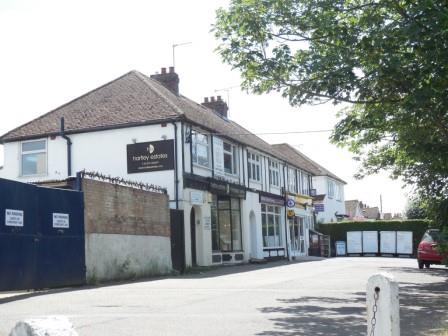
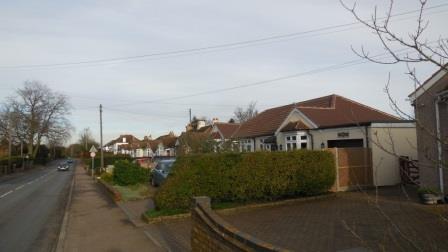 This section of Ash Road contains two of the service centres of the village. As well as the shops at the Church Road junction and Fairby Stores, this section also hosts the Church Hall, the WI (now Village) Hall, the Library, the Social Club and the businesses at Hartley Garage.
| Subject | Details |
| Length of Road | Part of Ash Road (in all 1.37 miles / 2.20 km) |
| KCC Reference | C252 |
| Acreage | 18.95a / 7.67ha |
| Number of houses | 95 |
| Population (2011) | 262 |
| Density | 5.0 houses per acre / 12.4 per hectare |

Rosecroft Ash Road DA3 7EL
Detached bungalow (4 bed)
Former Name(s): Hosecroft (to 1962)
Building History
1930 First Built
1957 Planning Application: (GRANTED) 1957/10242 Extension of 2nd bedroom
1965 Planning Application: (GRANTED) 1965/381 Private garage and access
1967 First Built
1999 Planning Application: (GRANTED) 1999/2280 Loft conversion
Rates and Council Tax
1956 Gross Rateable Value: £50
1963 Gross Rateable Value: £130
1972 Gross Rateable Value: £409
1993 Council Tax: F (£120-160K)
Sales and Rents
1996 Sale Price: £127000 (31 Oct 1996)
2006 Sale Price: £365000 (29 Aug 2006) Annual percentage change since 1996: +11%
Site History
1450 First Built
1905 Plots 305 & 306 Fawkham Park Estate
Westwood Ash Road DA3 7EL
Detached bungalow (2 bed)
Building History
1930 First Built
1955 Planning Application: (GRANTED) 1955/289 2 bungalows adjoining
1977 Planning Application: (REFUSED) 1977/792 Extension To Side Of Dwelling
1978 Planning Application: (GRANTED) 1978/106 Extension To Rear Of Dwelling
1980 Planning Application: (GRANTED) 1980/1017 REAR EXTENSION TO DWELLING
Rates and Council Tax
1956 Gross Rateable Value: £36
1963 Gross Rateable Value: £110
1963 Gross Rateable Value: £125
1972 Gross Rateable Value: £307
1993 Council Tax: F (£120-160K)
Sales and Rents
Site History
1450 Woodins Farm (Upper Well Field 5a)
1905 Plots 307 & 308 Fawkham Park Estate
Calfont Ash Road DA3 7EL
Detached bungalow (3 bed)
Former Name(s): Le Troiseme (to 1959)
Building History
1956 First Built
2009 Planning Application: (GRANTED) 2009/1879 Erection of a single storey rear extension, minor alterations to existing roof.
Rates and Council Tax
1963 Gross Rateable Value: £148
1972 Gross Rateable Value: £367
1993 Council Tax: F (£120-160K)
Sales and Rents
2009 Sale Price: £300000 (11 Mar 2009)
2010 Sale Price: £385000 (1 Dec 2010) Annual percentage change since 2009: +16%
Site History
1450 Woodins Farm (Upper Well Field 5a)
1905 First Built
Cramond Ash Road DA3 7EL
Detached bungalow
Building History
1956 First Built.
1986 First Built
1988 Planning Application: (GRANTED) 1988/421 Single storey rear extension
Rates and Council Tax
1963 Gross Rateable Value: £148
1972 Gross Rateable Value: £367
1993 Council Tax: F (£120-160K)
Sales and Rents
Site History
1450 Woodins Farm (Upper Well Field 5a)
1905 Plots 311-313 Fawkham Park Estate
Windy Ridge Ash Road DA3 7EL
4 bed (previously 2 bed)
Building History
1951 First Built. Licence to build 2.5.1950
1948 Planning Application: (GRANTED) 1948/19 Erect bungalow
1948 First Built
1963 Planning Application: (GRANTED) 1963/481 Alterations to form staircase, 2 rooms in roof space and toilet
1982 Planning Application: (GRANTED) 1982/678 Extension To Dwelling
2009 Planning Application: (REFUSED) 2009/2975 Demolition of existing detached garage, significant alteration to existing roof, erection of two storey side / rear extension, front dormer and two replacement rear dormers. New vehicle access and crossover.
2010 Planning Application: (GRANTED) 2010/2319 Demolish garage, erect 2 storey side and rear extension, new vehicle access
2013 Planning Application: (WITHDRAWN) 2013/2136 Extend time limit of 10/2319
Rates and Council Tax
1956 Gross Rateable Value: £42
1963 Gross Rateable Value: £135
1972 Gross Rateable Value: £392
1993 Council Tax: F (£120-160K)
Sales and Rents
2007 Sale Price: £385000 (26 Sep 2007)
2013 Sale Price: £415000 (9 Sep 2013) First Built Annual percentage change since 2007: +1%
2012 Rental (per month): £1500.
Site History
1450 Woodins Farm (Upper Well Field 5a)
1905 Plots 314-315 Fawkham Park Estate
3 The Parade Ash Road DA3 8BG
Building History
1934 First Built. DRDC Minutes (1.1.35) Completed since last report
1934 Planning Application: (GRANTED) 1934/Meeting 1934-03-06 5 shops and dwelling houses
1949 Planning Application: (GRANTED) 1949/77 Change of use to dairy and shop with living accommodation above
1966 Planning Application: (GRANTED) 1966/481 Alter ground floor to extend shop, form flat on 1st floor
1974 Planning Application: (REFUSED) 1974/Meeting Jan 74 Erection of garage and store building at rear
1982 Planning Application: (GRANTED) 1982/776 Retention Of Internally Illuminated Projecting Bo Sign And Hanging Window Sign
1983 Planning Application: (GRANTED) 1983/1642 USE OF FIRST FLOOR OF PREMISES AS INSURANCE CONSULTANCY OFFICES
2003 Planning Application: (GRANTED) 2003/507 Sun blind
2010 Planning Application: (GRANTED) 2010/807 Erection of a sign board with external illumination (retrospective).
2020 First Built
2020 Planning Application: (GRANTED) 2020/1079 Prior notification for a change of use from Office (B1), to Dwelling house (C3) and for building operations reasonably necessary for the conversion. This application is made under Class O of The Town and Country Planning (General Permitted Development) (England) Order 2015.
Rates and Council Tax
1956 Gross Rateable Value: £70
1963 Gross Rateable Value: £160
1972 Gross Rateable Value: £550
1995 Gross Rateable Value: £2450
2000 Gross Rateable Value: £2750
2005 Gross Rateable Value: £5650
Sales and Rents
1905 Sale Price: £249999 (30 Jun 1905)
Site History
1450 Woodins Farm (Hays Field 6a)
1912 First Built
1995 Gross Rateable Value: £1875
2000 Gross Rateable Value: £1850
2 The Parade Ash Road DA3 8BG
Building History
1934 First Built. DRDC Minutes (1.1.35) Completed since last report
1934 Planning Application: (GRANTED) 1934/Meeting 1934-03-06 5 shops and dwelling houses
1974 Planning Application: (REFUSED) 1974/399 THE ERECTION OF A TWO STOREY GARAGE BEDROOM AND BATHROOM EXTENSION AT SIDE
1974 Planning Application: (REFUSED) 1974/Meeting Jan 74 Office Extension at rear
Rates and Council Tax
1956 Gross Rateable Value: £72
1963 Gross Rateable Value: £140
1972 Gross Rateable Value: £240
1995 Gross Rateable Value: £3100
2000 Gross Rateable Value: £3600
2005 Gross Rateable Value: £4850
Sales and Rents
2020 Sale Price: £185000 (26 Jun 2020)
Site History
1450 Woodins Farm (Hays Field 6a)
1912 Rochford, Church Road, smallholding
1 The Parade Ash Road DA3 8BG
Building History
1934 First Built. DRDC Minutes (1.1.35) Completed since last report
1934 Planning Application: (GRANTED) 1934/Meeting 1934-03-06 5 shops and dwelling houses
1970 Planning Application: (GRANTED) 1970/595 Kitchen/dining room extension at rear
1988 Planning Application: (GRANTED) 1988/1759 Extension of shop premises at ground floor and extension of flat above at first floor level.
1990 Planning Application: (GRANTED) 1990/2024 Extension to shop premises and flat.Detached double garage.
1991 Planning Application: (GRANTED) 1991/302 Extension at ground floor to shop/garage further to approval ref.SE/90/2024
1992 First Built
1993 Planning Application: (REFUSED) 1993/1099 Display of one non-illuminated flat fixed panelsign.One internally illuminated double sided postmounted box sign.One internally illuminated double sided projecting box sign.
1993 Planning Application: (REFUSED) 1993/1219 Formation of additional bedroom in roof
1994 Planning Application: (GRANTED) 1994/262 Display of fascia sign and double sided projecting sign,as amended by letters and accompanying plans dated 19th April 1994,and 10th May 1994.
1994 Planning Application: (REFUSED) 1994/666 Removal of condition 2 of previous permission SE/91/0302
2005 Planning Application: (GRANTED) 2005/132 Retention of refrigeration unit (extractor fan and housing.)
2005 Planning Application: (GRANTED) 2005/1986 Use of garage as storage.
2005 Planning Application: (GRANTED) 2005/2477 Details pursuant to condition 1 (details of enclosure) of SE/05/00132/FUL dated 7 September 2005.
Rates and Council Tax
1956 Gross Rateable Value: £50
1963 Gross Rateable Value: £140
1972 Gross Rateable Value: £367
2005 Gross Rateable Value: £4650
Sales and Rents
2000 Sale Price: £165000 (25 Aug 2000)
2004 Sale Price: £300000 (13 Sep 2004) Annual percentage change since 2000: +16%
Site History
1450 First Built
1912 Rochford, Church Road, smallholding
13 (The Little House) Ash Road DA3 8BQ
Former Name(s): The White House (to 1968)
Building History
1935 First Built
1934 Planning Application: (GRANTED) 1934/Meeting 1934-10-02 2 storey brick dwelling house
1935 Planning Application: (GRANTED) 1935/Meeting 1935-02-05 Amended plan of brick dwelling house (tentative identification as no 13)
1987 Planning Application: (GRANTED) 1987/1464 Extension and garage
Rates and Council Tax
1956 Gross Rateable Value: £38
1963 Gross Rateable Value: £140
1972 Gross Rateable Value: £328
1993 Council Tax: E (£88-120K)
Sales and Rents
Site History
1450 Woodins Farm (Hays Field 6a)
1912 Rochford, Church Road, smallholding
12 Ash Road DA3 8BQ
First Built
Building History
1935 First Built
1933 Planning Application: (GRANTED) 1933/Meeting 1933-08-01 14 brick bungalows in pairs
2014 Planning Application: (GRANTED) 2014/3678 Prior notification of a single storey rear extension which extends 5.6m beyond the rear wall of the original dwelling house with a maximum height of 3.261m and eaves height of 2.38m.
Rates and Council Tax
1956 Gross Rateable Value: £25
1963 Gross Rateable Value: £101
1972 Gross Rateable Value: £232
1993 Council Tax: D (£68-88K) Formerly band E
Sales and Rents
1996 Sale Price: £78000 (4 Jan 1996)
2010 Sale Price: £239995 (21 Jun 2010) First Built Annual percentage change since 1996: +8%
2020 Sale Price: £425000 (11 Nov 2020) Marketed Price. Previously marketed in 2018 for £400,000 Annual percentage change since 2010: +6%
2021 Sale Price: £425000 (15 Mar 2021) Planning permissions since previous sale Annual percentage change since 2020: +%
Site History
1450 Woodins Farm (Hays Field 6a)
1912 Rochford, Church Road, smallholding
11 Ash Road DA3 8BQ
Semi-detached bungalow (3 bedroom, 101.3 sq m + conservatory 19 sq m)
Building History
1935 First Built
1933 Planning Application: (GRANTED) 1933/Meeting 1933-08-01 14 brick bungalows in pairs
1995 Planning Application: (GRANTED) 1995/948 Side Extension.
1995 Planning Application: (GRANTED) 1995/1541 Details of scheme to maintain the privacy of adjoining dwellingpursuant to condition 3 of planning permission SE/95/0948.
Rates and Council Tax
1956 Gross Rateable Value: £25
1963 Gross Rateable Value: £101
1972 Gross Rateable Value: £242
1993 Council Tax: E (£88-120K)
Sales and Rents
1995 Sale Price: £84000 (23 Mar 1995)
2021 Sale Price: £402000 (14 Jun 2021) Planning permissions since previous sale Annual percentage change since 1995: +6%
2025 Sale Price: £430000 (9 May 2025) Advertised price Annual percentage change since 2021: +2%
Site History
1450 Woodins Farm (Hays Field 6a)
1912 Rochford, Church Road, smallholding
10 Ash Road DA3 8BQ
3 bed
Former Name(s): Dawburn (to 1934)
Building History
1934 First Built
1933 First Built
2004 Planning Application: (GRANTED) 2004/3155 Demolish garage, replace with side and rear extensions
Rates and Council Tax
1956 Gross Rateable Value: £26
1963 Gross Rateable Value: £103
1972 Gross Rateable Value: £261
1993 Council Tax: E (£88-120K)
Sales and Rents
1934 Sale Price: £600 (9 May 1934)
2005 Sale Price: £222000 (18 Feb 2005) Annual percentage change since 1934: +9%
2014 Sale Price: £380000 (13 Jun 2014) Annual percentage change since 2005: +6%
Site History
1450 Woodins Farm (Hays Field 6a)
1912 Rochford, Church Road, smallholding
9 Ash Road DA3 8BQ
Building History
1935 First Built
1933 Planning Application: (GRANTED) 1933/Meeting 1933-08-01 14 brick bungalows in pairs
2022 Planning Application: (GRANTED) 2022/2792 Single storey side extension
Rates and Council Tax
1956 Gross Rateable Value: £25
1963 Gross Rateable Value: £101
1972 Gross Rateable Value: £222
1993 Council Tax: E (£88-120K) With improvement indicator (2025)
Sales and Rents
2005 Sale Price: £192500 (9 Sep 2005)
Site History
1450 Woodins Farm (Hays Field 6a)
1912 Rochford, Church Road, smallholding
8 Ash Road DA3 8BQ
Building History
1935 First Built
1933 Planning Application: (GRANTED) 1933/Meeting 1933-08-01 14 brick bungalows in pairs
Rates and Council Tax
1956 Gross Rateable Value: £29
1963 Gross Rateable Value: £116
1972 Gross Rateable Value: £281
1993 Council Tax: E (£88-120K)
Sales and Rents
2005 Sale Price: £188500 (23 May 2005)
Site History
1450 Woodins Farm (Hays Field 6a)
1912 Rochford, Church Road, smallholding
7 Ash Road DA3 8BQ
Building History
1935 First Built
1933 Planning Application: (GRANTED) 1933/Meeting 1933-08-01 14 brick bungalows in pairs
1993 Planning Application: (GRANTED) 1993/602 Extension to form granny annexe
2016 Planning Application: (GRANTED) 2016/693 Erect front porch and rear conservatory
Rates and Council Tax
1956 Gross Rateable Value: £25
1963 Gross Rateable Value: £101
1972 Gross Rateable Value: £222
1993 Council Tax: D (£68-88K) Formerly band E; with improvement indicator
Sales and Rents
1962 Sale Price: £2400 (5 Apr 1962)
1977 Sale Price: £12995 (26 Oct 1977) Annual percentage change since 1962: +11%
1999 Sale Price: £145000 (8 Sep 1999) Annual percentage change since 1977: +12%
2004 Sale Price: £250000 (12 Jan 2004) Annual percentage change since 1999: +13%
2015 Sale Price: £375000 (31 Dec 2015) Advertised at £385000 Annual percentage change since 2004: +3%
Site History
1450 Woodins Farm (Hays Field 6a)
1912 Rochford, Church Road, smallholding
6 Ash Road DA3 8BQ
Building History
1935 First Built
1933 Planning Application: (GRANTED) 1933/Meeting 1933-08-01 14 brick bungalows in pairs
1950 Planning Application: (GRANTED) 1950/40 Enlarge dining room
Rates and Council Tax
1956 Gross Rateable Value: £28
1963 Gross Rateable Value: £111
1972 Gross Rateable Value: £245
1993 Council Tax: E (£88-120K)
Sales and Rents
Site History
1589 Middle Farm (Shaw ¼a)
1912 Rochford, Church Road, smallholding
5 Ash Road DA3 8BQ
Semi-detached bungalow (2 bedroom - 1979)
Building History
1935 First Built
1933 Planning Application: (GRANTED) 1933/Meeting 1933-08-01 14 brick bungalows in pairs
Rates and Council Tax
1956 Gross Rateable Value: £27
1963 Gross Rateable Value: £106
1972 Gross Rateable Value: £256
1993 Council Tax: E (£88-120K)
Sales and Rents
1979 Sale Price: £33500 (31 Aug 1979) Advertised price
2018 Sale Price: £300000 (19 Jan 2018) Annual percentage change since 1979: +6%
Site History
1589 Middle Farm (part of 12a Lower Homefield)
1912 Rochford, Church Road, smallholding
4 Ash Road DA3 8BQ
2 Bed
Building History
1935 First Built
1933 Planning Application: (GRANTED) 1933/Meeting 1933-08-01 14 brick bungalows in pairs
1952 Planning Application: (GRANTED) 1952/6510 Private Garage
2017 Planning Application: (REFUSED) 2017/1329 Partial demolition of existing conservatory and erection of a single storey rear extension, existing garage converted into habitable and conversion of roof void with dormer to rear elevation. Increase in roof height on the right flank alteration to fenestration which includes new porch.
2017 Planning Application: (GRANTED) 2017/2403 Partial demolition of existing conservatory and erection of a single storey rear extension. Demolition of existing garage to facilitate the erection of a single storey side extension. Alterations to fenestration. Refurbishment, Single Storey Rear Extension and Conversion of Garage to Habitable Accommodation
Rates and Council Tax
1956 Gross Rateable Value: £25
1963 Gross Rateable Value: £101
1972 Gross Rateable Value: £242
1993 Council Tax: E (£88-120K) With improvement indicator
Sales and Rents
2012 Sale Price: £230000 (17 May 2012)
2013 Sale Price: £250000 (22 Nov 2013) Annual percentage change since 2012: +6%
2015 Sale Price: £285000 (10 Apr 2015) Annual percentage change since 2013: +10%
2017 Sale Price: £345000 (10 Mar 2017) Annual percentage change since 2015: +10%
2021 Sale Price: £442000 (29 Jan 2021) Planning permissions since last sale Annual percentage change since 2017: +7%
Site History
1589 Middle Farm (part of 12a Lower Homefield)
1912 Rochford, Church Road, smallholding
3 (Bracken) Ash Road DA3 8BQ
Building History
1935 First Built
1933 Planning Application: (GRANTED) 1933/Meeting 1933-08-01 14 brick bungalows in pairs
Rates and Council Tax
1956 Gross Rateable Value: £25
1963 Gross Rateable Value: £101
1972 Gross Rateable Value: £222
2000 Council Tax: E (£88-120K) Formerly Band E (1993), then Band D (1993)
Sales and Rents
1996 Sale Price: £50000 (18 Oct 1996)
2000 Sale Price: £163000 (28 Apr 2000) Annual percentage change since 1996: +40%
Site History
1589 Middle Farm (part of 12a Lower Homefield)
1912 Rochford, Church Road, smallholding
2 Ash Road DA3 8BQ
Building History
1935 First Built
1933 Planning Application: (GRANTED) 1933/Meeting 1933-08-01 14 brick bungalows in pairs
1934 Planning Application: (GRANTED) 1934/Meeting 1934-03-06 5 shops and dwelling houses
1987 Planning Application: (GRANTED) 1987/499 Extension
Rates and Council Tax
1956 Gross Rateable Value: £25
1963 Gross Rateable Value: £101
1972 Gross Rateable Value: £222
1993 Council Tax: E (£88-120K)
Sales and Rents
Site History
1589 Middle Farm (part of 12a Lower Homefield)
1912 Rochford, Church Road, smallholding
1 (Flamstead) Ash Road DA3 8BQ
Detached bungalow (4 bed)
Building History
1935 First Built
1933 Planning Application: (GRANTED) 1933/Meeting 1933-08-01 14 brick bungalows in pairs
1947 Planning Application: (GRANTED) 1947/4364 garage
2005 Planning Application: (GRANTED) 2005/132 Retain Refrigeration unit
2005 Planning Application: (GRANTED) 2005/1986 Use garage as storage
Rates and Council Tax
1956 Gross Rateable Value: £27
1963 Gross Rateable Value: £108
1972 Gross Rateable Value: £236
1993 Council Tax: E (£88-120K)
Sales and Rents
1997 Sale Price: £89995 (19 Jun 1997)
2020 Rental (per month): £1850.
Site History
1589 Middle Farm (part of 12a Lower Homefield)
1912 Rochford, Church Road, smallholding
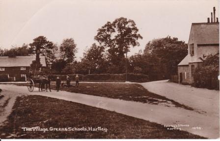
Hartley CE School Ash Road DA3 8BQ
Building History
1841 First Built
1969 Building demolished
1940 Planning Application: (GRANTED) 1940/3166 Air raid shelter
1940 Planning Application: (GRANTED) 1940/3180 School canteen
1951 Planning Application: (GRANTED) 1951/153 Temporary Church Hall
1957 Planning Application: (N/A) 1957/55 Add classroom accm
Rates and Council Tax
1956 Gross Rateable Value: £
1963 Gross Rateable Value: £
Sales and Rents
Site History
1589 Middle Farm (part of 12a Lower Homefield)
School House Ash Road DA3 8BQ
Building History
1841 First Built. Incorporated into school as a staffroom 1961
1969 Building demolished
Rates and Council Tax
1956 Gross Rateable Value: £12
1963 Gross Rateable Value: £27
Sales and Rents
Site History
1589 Middle Farm (part of 12a Lower Homefield)
Killara Ash Road DA3 8BQ
Building History
1971 First Built
1969 Planning Application: (GRANTED) 1969/74 Erect 3 dwellings with garages on site of CE School
1969 Planning Application: (GRANTED) 1969/74.1 Details of parking v 69/74 (application dated 27.3.69)
2003 Planning Application: (GRANTED) 2003/574 Details of footpath construction pursuant to condition 5 of planning permission SE/98/2259,as amended by letter dated 8.2.00.
Rates and Council Tax
1993 Council Tax: F (£120-160K)
Sales and Rents
1970 Sale Price: £8950 (19 Jun 1970) Advertised price
1999 Sale Price: £135000 (8 Jun 1999) Annual percentage change since 1970: +10%
Site History
1589 Middle Farm (part of 12a Lower Homefield)
1841 Site of original Hartley Primary School
Greenwood Ash Road DA3 8BQ
3 bed
Building History
1971 First Built
1969 Planning Application: (GRANTED) 1969/74 Erect 3 dwellings with garages on site of CE School
1969 Planning Application: (GRANTED) 1969/74.1 Details of parking v 69/74 (application dated 27.3.69)
Rates and Council Tax
1993 Council Tax: E (£88-120K) Formerly Band F (1993)
Sales and Rents
2013 Sale Price: £240000 (22 Mar 2013)
Site History
1589 Middle Farm (part of 12a Lower Homefield)
1841 Site of original Hartley Primary School
Tanooma Ash Road DA3 8BQ
Building History
1971 First Built
1969 Planning Application: (GRANTED) 1969/74 Erect 3 dwellings with garages on site of CE School
1969 Planning Application: (GRANTED) 1969/74.1 Details of parking v 69/74 (application dated 27.3.69)
Rates and Council Tax
1993 Council Tax: E (£88-120K) Formerly Band F (1993)
Sales and Rents
1970 Sale Price: £8650 (19 Jun 1970) Advertised price
Site History
1589 Middle Farm (part of 12a Lower Homefield)
1841 Site of original Hartley Primary School
1924 Planning Application: (GRANTED) 1924/Meeting 1924-09-10 Cement and rough cast bungalow
1949 Planning Application: (GRANTED) 1949/363 Use of land as training ground for greyhounds
1956 Planning Application: (REFUSED) 1956/416 Erect bungalow on land adjoining
1957 Planning Application: (GRANTED) 1957/166 Caravan
1964 Planning Application: (GRANTED) 1964/396.1 Details of new bathroom
2015 Planning Application: (GRANTED) 2015/1828 Provision of new roof incorporating 3 bedrooms and bathroom, with 2 dormers to the front and 1 dormer to the rear.
2018 Planning Application: (REFUSED) 2018/2352 Erection of detached double garage.
White Gables Ash Road DA3 8EN
Semi-detached house (3 bedroom - 1971)
Building History
1966 First Built
1956 Planning Application: (REFUSED) 1956/416 (site of) see Clifton
1979 Planning Application: (GRANTED) 1979/748 CONSERVATORY EXTENSION TO REAR OF DWELLING
1995 Planning Application: (GRANTED) 1995/1648 Single storey rear extension and front porch.
Rates and Council Tax
1972 Gross Rateable Value: £332
1993 Council Tax: E (£88-120K)
Sales and Rents
1971 Sale Price: £9500 (30 Jul 1971) Advertised price (Maidstone Telegraph)
1996 Sale Price: £114000 (19 Apr 1996) Annual percentage change since 1971: +11%
2006 Sale Price: £287500 (27 Nov 2006) Annual percentage change since 1996: +9%
Site History
1589 First Built
1912 Part of Clifton smallholding
Tamarix Ash Road DA3 8EN
Semi-detached house (3 bed)
Building History
1966 First Built
1956 First Built
Rates and Council Tax
1972 Gross Rateable Value: £332
1993 Council Tax: E (£88-120K)
Sales and Rents
2014 Sale Price: £360000 (18 Feb 2014)
Site History
1589 Middle Farm (part of 12a Lower Homefield)
1912 Part of Clifton smallholding
Appledore Ash Road DA3 8EN
Semi-detached house (4 bed)
Building History
1966 First Built
1953 First Built
1956 Planning Application: (REFUSED) 1956/416 (site of) see Clifton
1970 Planning Application: (REFUSED) 1970/139 Residential development (outline)
1985 Planning Application: (REFUSED) 1985/1240 ADDITIONAL ACCESS TO EXISTING GARAGE
1987 Planning Application: (REFUSED) 1987/2127 DETACHED DWELLING WITH DOUBLE GARAGE
1988 Planning Application: (GRANTED) 1988/2589 Single storey rear extension .
Rates and Council Tax
1972 Gross Rateable Value: £322
1993 Council Tax: E (£88-120K)
Sales and Rents
Site History
1589 Middle Farm (part of 12a Lower Homefield)
1912 Part of Clifton smallholding
Gavarnie Ash Road DA3 8EN
Semi-detached house
Semi-detached house (3 bed)
Building History
1966 First Built
2022 Planning Application: (GRANTED) 2022/3453 Ground and first floor extensions to rear and side, incorporating existing garage. Roof alterations.
Rates and Council Tax
1972 Gross Rateable Value: £322
1993 Council Tax: E (£88-120K)
Sales and Rents
2003 Sale Price: £260000 (6 Mar 2003)
2018 Sale Price: £485000 (30 Oct 2018) Annual percentage change since 2003: +4%
2022 Sale Price: £570000 (26 Aug 2022) Annual percentage change since 2018: +4%
2016 Rental (per month): £1450.
Site History
1589 Middle Farm (part of 12a Lower Homefield)
1912 Part of Clifton smallholding
Homefield Ash Road DA3 8EN
Building History
1915 First Built
1974 Building demolished
1970 Planning Application: (GRANTED) 1970/182 Alter vehicular access
Rates and Council Tax
1956 Gross Rateable Value: £42
1963 Gross Rateable Value: £150
1972 Gross Rateable Value: £329
Sales and Rents
Site History
Somerville Ash Road DA3 8EL
Detached house
Building History
1974 First Built
1974 Planning Application: (GRANTED) 1974/Meeting Feb 74 Erect 4 dwellings on site of Homefield
1978 Planning Application: (GRANTED) 1978/942 Continued Stationing Of A Residential Caravan (Renewal Of Limited Period Planning Permission Se/77/1150)
1995 Planning Application: (WITHDRAWN) 1995/740 Two storey side extension incorporating integral garage
1995 Planning Application: (GRANTED) 1995/1483 Proposed garage extension.
1995 Planning Application: (GRANTED) 1995/2212 Details of facing materials pursuant to condition 2 of planning permission SE/95/1483 dated 28/9/95.
1997 Planning Application: (N/A) 1997/2537 1st floor extension and bathroom
Rates and Council Tax
1993 Council Tax: G (£160-320K)
Sales and Rents
1979 Sale Price: £88750 (22 Nov 1979) Advertised at £88,750 (Dartford Chron)
1994 Sale Price: £175000 (9 Sep 1994) Annual percentage change since 1979: +5%
Site History
1589 Middle Farm (part of Upper Homefield, 9a)
1912 Part of Homefield, Ash Road smallholding
Marralomeda Ash Road DA3 8EL
Detached house (4 bed)
Building History
1974 First Built
1974 Planning Application: (GRANTED) 1974/Meeting Feb 74 Erect 4 dwellings on site of Homefield
1990 Planning Application: (GRANTED) 1990/1149 Single storey rear extension
Rates and Council Tax
1993 Council Tax: G (£160-320K) First Built
Sales and Rents
2001 Sale Price: £235000 (9 Feb 2001)
2015 Sale Price: £629995 (13 Nov 2015) Annual percentage change since 2001: +7%
2017 Sale Price: £620000 (2 Oct 2017) Annual percentage change since 2015: -1%
2020 Sale Price: £645000 (28 Sep 2020) Annual percentage change since 2017: +1%
Site History
1589
1912
Pinecroft Ash Road DA3 8EL
Detached house (5 bed)
Building History
1974 First Built
1974 First Built
1981 Planning Application: (GRANTED) 1981/278 RETENTION OF EXISTING BRICK WALL, PIERS AND GATE
1993 Planning Application: (GRANTED) 1993/439 Side kitchen extension
2002 Planning Application: (GRANTED) 2002/918 Rear Conservatory
2024 Planning Application: (GRANTED) 2024/00097 Removal of a Hespercyparis macrocarpa Notes: No objection lodged
Rates and Council Tax
1993 Council Tax: F (£120-160K) Formerly Band G (1993)
Sales and Rents
2012 Sale Price: £445000 (30 Apr 2012)
Site History
1589
1912 First Built
The Croft Ash Road DA3 8EL
Detached House (5 bed)
Building History
1917 First Built
1966 Planning Application: (WITHDRAWN) 1966/425 Use of front garden as Social Club car park - for 30 cars or to use whole premises as Social Club
1975 Planning Application: (REFUSED) 1975/993 Demolition Of Existing Timber Sheds And Erection Of Detached Bungalow And Garage
1975 Planning Application: (GRANTED) 1975/1137 Erection Of Replacement Single Storey Utility Room And Entrance Extension At Side
1989 Planning Application: (REFUSED) 1989/922 Demolish 4 houses; erect 13
1990 Planning Application: (N/A) 1990/548 Demolish 4 houses, erect 11
1994 First Built
1995 Planning Application: (GRANTED) 1995/952 Details of roofing materials pursuant to condition 2 of planning permission SE/94/1624.
1998 Planning Application: (GRANTED) 1998/605 Replacement garage and stores
2000 Planning Application: (GRANTED) 2000/13 Increase width of pavement crossover
2001 Planning Application: (GRANTED) 2001/2552 Single storey rear extension
Rates and Council Tax
1956 Gross Rateable Value: £28
1963 Gross Rateable Value: £110
1972 Gross Rateable Value: £263
1993 Council Tax: F (£120-160K)
Sales and Rents
1966 Sale Price: £5250 (18 Jul 1966) First Built
2024 Sale Price: £1310000 (30 May 2024) Annual percentage change since 1966: +10%
Site History
1589 Middle Farm (part of Upper Homefield, 9a)
1912 Part of The Croft, Ash Road smallholding
White Stock Ash Road DA3 8EL
Detached House
Building History
1961 First Built
2005 Building demolished
2007 Rebuilt
1960 First Built
1960 Planning Application: (GRANTED) 1960/6.1 Erect semi-bungalow adjoining The Croft
1976 Planning Application: (NOT KNOWN) 1976/670 Extension To Side And Rear Of Dwelling Incorporating A Garage
1985 Planning Application: (GRANTED) 1985/338 Stationing of commercial vehicle
1989 Planning Application: (REFUSED) 1989/922 Demolish 4 houses; erect 13
1990 Planning Application: (N/A) 1990/548 Demolish 4 houses, erect 11
2005 Planning Application: (GRANTED) 2005/393 Demolish, replace with 5 bed house
2005 Planning Application: (GRANTED) 2005/1451 Details pursuant to Conditions 2 (samples of materials) and Condition 3 (landscaping) of SE/05/00393/FUL.
2005 Planning Application: (GRANTED) 2005/1885 Details of drainage (v 2005/393)
Rates and Council Tax
1963 Gross Rateable Value: £153
1972 Gross Rateable Value: £390
2007 Council Tax: G (£160-320K) Formerly Band F (1993-2005)
Sales and Rents
2004 Sale Price: £450000 (20 Dec 2004)
Site History
1589 Middle Farm (part of Upper Homefield, 9a)
1912 Part of The Croft, Ash Road smallholding
The Anchorage Ash Road DA3 8EL
Detached house (7 bed)
Former Name(s): Half Acre (to 1963); Langdale (1963-1968)
Building History
1949 First Built
1971 Planning Application: (REFUSED) 1971/226 6 feet tall boundary wall
1986 First Built
1986 Planning Application: (N/A) 1986/495 Lounge extension
1989 Planning Application: (REFUSED) 1989/922 Demolish 4 houses; erect 13
1990 Planning Application: (N/A) 1990/548 Demolish 4 houses, erect 11
1994 Planning Application: (GRANTED) 1994/1284 Single storey rear extension
1994 Planning Application: (GRANTED) 1994/1284 Single storey rear extension
2001 Planning Application: (GRANTED) 2001/1966 2 storey side and single storey front extension
2002 Planning Application: (GRANTED) 2002/636 Revisions to 01/1966
2002 Planning Application: (GRANTED) 2002/1875 2 storey side extenion; front garage
2003 Planning Application: (GRANTED) 2003/2869 New vehicular access, and erect wooden pool house
2004 Planning Application: (GRANTED) 2004/3021 Single storey garage extension
2006 Planning Application: (GRANTED) 2006/527 Entrance Porch to front elevation
2006 Planning Application: (GRANTED) 2006/974 Details (materials) v 06/527
2009 Planning Application: (GRANTED) 2009/1110 2 storey extension to front with replacement porch, single storey extension and conservatory to rear
2010 First Built
2018 Planning Application: (REFUSED) 2018/3219 Single storey garage and car port extension.
2019 Planning Application: (REFUSED) 2019/114 Proposed single storey double garage.
2019 Planning Application: (REFUSED) 2019/3201 Proposed detached open timber framed car port providing parking for two cars
2020 Planning Application: (GRANTED) 2020/385 Existing garage extension.
Rates and Council Tax
1956 Gross Rateable Value: £48
1963 Gross Rateable Value: £170
1972 Gross Rateable Value: £395
1993 Council Tax: G (£160-320K) With improvement indicator (2020)
Sales and Rents
1953 Sale Price: £3300 (1 Dec 1953) Surveyor's valuation for loan to Dartford RDC of £2,000 over 20 years at 4¼%
2001 Sale Price: £449000 (13 Dec 2001) Annual percentage change since 1953: +11%
2003 Sale Price: £740000 (8 May 2003) Annual percentage change since 2001: +43%
Site History
1589 Middle Farm (part of Upper Homefield, 9a)
1912 First Built
Meadcot Ash Road DA3 8EL
Detached House (4 bed)
Building History
1924 First Built
1978 Rebuilding
1923 Planning Application: (GRANTED) 1923/Meeting 1923-12-04 Brick cottage
1924 First Built
1978 Planning Application: (GRANTED) 1978/496 Demolition Of Existing And Erection Of Replacement Detached House And Garage
1989 Planning Application: (REFUSED) 1989/922 Demolish 4 houses; erect 13
1990 Planning Application: (N/A) 1990/548 Demolish 4 houses, erect 11
Rates and Council Tax
1956 Gross Rateable Value: £31
1963 Gross Rateable Value: £110
1972 Gross Rateable Value: £261
1993 Council Tax: G (£160-320K)
Sales and Rents
Site History
1589 Middle Farm (part of Upper Homefield, 9a)
1912 Part of The Croft, Ash Road smallholding
Wayside Ash Road DA3 8EL
Detached House
Building History
1918 Rebuilt
1960 Planning Application: (GRANTED) 1960/91 Stationing of caravan
1971 First Built
1987 Planning Application: (GRANTED) 1987/1398 Extension and canopy
1994 Planning Application: (REFUSED) 1994/643 Detached granny annexe.
2018 Planning Application: (GRANTED) 2018/60 Demolition of car port, rear extension and part of the garage, Erection of a part two storey/single storey rear extension with rooflight. Erection of a front porch, rooflight to the front and alterations to fenestration.
Rates and Council Tax
1956 Gross Rateable Value: £29
1963 Gross Rateable Value: £105
1972 Gross Rateable Value: £236
1993 Council Tax: G (£160-320K) With improvement indicator (2020)
Sales and Rents
2017 Sale Price: £807500 (5 Oct 2017)
Site History
1589 Middle Farm (part of Upper Homefield, 9a)
1912 Part of Wayside, Ash Road smallholding
Knoll Cottage Ash Road DA3 8EL
Former Name(s): St Anthonys (to 1953)
Building History
1939 First Built
1960 Planning Application: (REFUSED) 1960/570 Erect dwelling at rear of
1961 Planning Application: (REFUSED) 1961/461 Erect bungalow on land at rear
1969 Planning Application: (GRANTED) 1969/644 2 storey extension to provide kitchen, bathroom and bedroom
1973 Planning Application: (GRANTED) 1973/Meeting Jun 73 Extension to garage
1981 Planning Application: (GRANTED) 1981/1646 Single storey side extension
1989 Planning Application: (GRANTED) 1989/304 2 storey side and 1st floor extenison
2011 Planning Application: (REFUSED) 2011/2211 Double garage with playroom above
2012 Planning Application: (REFUSED) 2012/1751 Double garage
2012 Planning Application: (REFUSED) 2012/3176 Double garage
2013 Planning Application: (GRANTED) 2013/2706 Single storey rear extension
2013 First Built
2021 Planning Application: (GRANTED) 2021/3420 Two storey front extension. Alterations to fenestration.
Rates and Council Tax
1956 Gross Rateable Value: £35
1963 Gross Rateable Value: £130
1972 Gross Rateable Value: £376
1993 Council Tax: G (£160-320K)
Sales and Rents
1913 Sale Price: £47.75 (15 Jan 1913) Land only
1953 Sale Price: £2500 (22 Oct 1953) Annual percentage change since 1913: +10%
Site History
1589 Middle Farm (part of Upper Homefield, 9a)
1912 First Built
Library Ash Road DA3 8EL
Building History
1968 First Built
1966 Planning Application: (GRANTED) 1966/409 Branch Library
1976 Planning Application: (WITHDRAWN) 1976/1017 Erection Of A Branch Library
2004 Planning Application: (GRANTED) 2004/1634 Alteration to form new Parish Council Office.
Rates and Council Tax
2005 Gross Rateable Value: £9250
2010 Gross Rateable Value: £9100
Sales and Rents
1905 Sale Price: £ (17 May 1905)
Site History
1589 Middle Farm (part of Upper Homefield, 9a - part of 1a hopfield in 1844
1912 Part of The Knoll, Ash Road smallholding (Small Owners Ltd ref 25)
2005 Gross Rateable Value: £1550
2009 Gross Rateable Value: £1000
2010 Gross Rateable Value: £2150
Hartley Garage Ash Road DA3 8EL
Building History
1927 First Built. Based on move of address of company to here
1927 First Built
1927 Planning Application: (GRANTED) 1927/Meeting 1927-10-04 Petrol pump
1930 Planning Application: (GRANTED) 1930/Meeting 1930-07-01 Petrol pump and tank
1948 Planning Application: (GRANTED) 1948/72 Erect agricultural store at rear (Hartley Agricultural Coop)
1948 Planning Application: (GRANTED) 1948/72 Erect agricultural store at rear
1958 Planning Application: (GRANTED) 1958/353 Timber framed asbestos clad storage and packing building at rear
1961 Planning Application: (REFUSED) 1961/218 Erect workshop and stores for sheet metal work and welding at rear of Cornford General Supplies Store formerly Hartley Agricultural Co-operative Society
1961 Planning Application: (GRANTED) 1961/331 Convert attic into self contained flat (Cronford General Supplies)
1970 Planning Application: (WITHDRAWN) 1970/300 New pump island and canopy (Ultramar)
1970 Planning Application: (GRANTED) 1970/678 Erect "Atcost" building for repair of vehicles
1974 First Built
1974 Planning Application: (REFUSED) 1974/Meeting Feb 74 Erect storage building (OS 60586746)
1974 Planning Application: (REFUSED) 1974/Meeting Feb 74 Erect car wash
1975 Planning Application: (REFUSED) 1975/513 Erection Of Car Wash And Formation Of A Hard Standing
1979 Planning Application: (REFUSED) 1979/1296 ERECTION OF EXTENSIONS TO EXISTING BUILDING TO PROVIDE ADDITIONAL WORKSHOP AREAS
1982 Planning Application: (GRANTED) 1982/1236 Erection Of Canopy To Premises
1985 Planning Application: (GRANTED) 1985/1307 Demolish temporary building, erect single storey reception and storage building
1986 Planning Application: (REFUSED) 1986/1465 Erect 3 workshops
1987 Planning Application: (GRANTED) 1987/489 DETACHED GARAGE
1996 Planning Application: (GRANTED) 1996/1843 Construction of single storey office extension.
1999 Planning Application: (OBJECT) 1999/2731 Prior notification for the installation of a 15m high flagpole supporting 3 sectioned antennae together with ground based equipment.
2020 Planning Application: (REFUSED) 2020/283 Change of use of the rear part of the motor vehicle repair and MOT centre from B2 (general industrial) to a mixed B2 and B8 use (to allow for storage and distribution) together with the retention of two storage containers in connection with the B2 use and the siting of nine additional storage containers for B8 storage use, re-arrangement of parking and landscaping.
2020 Planning Application: (GRANTED) 2020/2296 Change of use of the rear part of the motor vehicle repair and MOT centre from B2 (general industrial) to a mixed B2 and B8 use (to allow for storage and distribution) together with the retention of two storage containers in connection with the B2 use and the siting of nine additional storage containers for B8 storage use.
Rates and Council Tax
1956 Gross Rateable Value: £163
1963 Gross Rateable Value: £450
1972 Gross Rateable Value: £825
2005 Gross Rateable Value: £30140
Sales and Rents
Site History
1421 Part of Fairby Farm (unnamed 2a hopfield in 1844)
1912 Hartley Garage Smallholding
WI Hall Ash Road DA3 8EL
Building History
0 First Built
1971 Building demolished
1975 Rebuilding
1925 Planning Application: (GRANTED) 1925/Meeting 1925-08-04 Hartley WI timber framed lined asbestos
1928 Planning Application: (GRANTED) 1928/Meeting 1928-07-31 New kitchen and cloakroom
1979 Planning Application: (GRANTED) 1979/1113 Erect detached store room at rear
2003 Planning Application: (GRANTED) 2003/191 Disabled toilet
Rates and Council Tax
1956 Gross Rateable Value: £19
1963 Gross Rateable Value: £
2005 Gross Rateable Value: £2500
2010 Gross Rateable Value: £2650
Sales and Rents
Site History
1421 Part of Fairby Farm (unnamed 2a hopfield in 1844)
1912 Hartley Garage Smallholding
URC Church Ash Road DA3 8EL
Building History
1934 First Built
1934 Planning Application: (GRANTED) 1934/Meeting 1934-05-01 Brick Congregational Church
1934 Planning Application: (GRANTED) 1934/Meeting 1934-05-01 Brick Congregational Church
1938 Planning Application: (GRANTED) 1938/2808 Brick Church Hall
2008 Planning Application: (WITHDRAWN) 2008/1308 Demolish replace with 8 flats
2009 Planning Application: (REFUSED) 2009/1679 Demolish, build 6 x 2 bed flats
2012 Planning Application: (GRANTED) 2012/1509 Demolish replace with 2 flats and 3 bungalows
2012 Planning Application: (GRANTED) 2012/3032 Details pursuant to condition 2 (samples of materials) v 12/01509
2012 Planning Application: (GRANTED) 2012/3034 Details pursuant to condition 6 (refuse/cycle store) v 12/01509
2012 First Built
2012 Planning Application: (GRANTED) 2012/3036 Details pursuant to condition 9 (PART) (code for sustainable homes)v 12/01509
2012 Planning Application: (GRANTED) 2012/3037 Details pursuant to condition 12 (construction method statement) v 12/01509
2012 Planning Application: (GRANTED) 2012/3130 Details pursuant to condition 10 (biodiversity enhancement)v 12/01509
2014 Planning Application: (GRANTED) 2014/168 Details pursuant to condition 3 (hard & soft landscaping) of planning permission SE/12/01509/FUL
2014 Planning Application: (GRANTED) 2014/207 Details pursuant to condition 7 (external lighting) of planning permission SE/12/01509/FUL
Rates and Council Tax
1956 Gross Rateable Value: £
1963 Gross Rateable Value: £Exempt
1972 Gross Rateable Value: £
Sales and Rents
Site History
1421 Part of Fairby Farm (unnamed 2a hopfield in 1844)
1912 Hartley Garage Smallholding
1 Ellerby Mews Ash Road DA3 8ER
Flat (2 bed)
Building History
2013 First Built. Completed 29/11/2013
Rates and Council Tax
2013 Council Tax: C (£52-68K)
Sales and Rents
2013 Sale Price: £230000 (29 Nov 2013)
2016 Sale Price: £295000 (21 Dec 2016) First Built Annual percentage change since 2013: +8%
Site History
1421 Part of Fairby Farm (unnamed 2a hopfield in 1844)
1912 Hartley Garage Smallholding
2 Ellerby Mews Ash Road DA3 8ER
Flat (2 bed)
Building History
2013 First Built. Completed 6/12/2013
Rates and Council Tax
2013 Council Tax: C (£52-68K)
Sales and Rents
2013 Sale Price: £215000 (6 Dec 2013)
Site History
1421 Part of Fairby Farm (unnamed 2a hopfield in 1844)
1912 Hartley Garage Smallholding
3 Ellerby Mews Ash Road DA3 8ER
First Built
Building History
2014 First Built. Completed 20/1/2014
Rates and Council Tax
2013 Council Tax: E (£88-120K)
Sales and Rents
2014 Sale Price: £295000 (22 May 2014)
Site History
1421 Part of Fairby Farm (unnamed 2a hopfield in 1844)
1912 Hartley Garage Smallholding
4 Ellerby Mews Ash Road DA3 8ER
Terraced house
Building History
2014 First Built. Completed 13/1/2014
Rates and Council Tax
2013 Council Tax: E (£88-120K)
Sales and Rents
2014 Sale Price: £295000 (13 Jan 2014)
Site History
1421 Part of Fairby Farm (unnamed 2a hopfield in 1844)
1912 Hartley Garage Smallholding
5 Ellerby Mews Ash Road DA3 8ER
First Built
Building History
2013 First Built. Completed 20/11/2013
2015 Planning Application: (REFUSED) 2015/3987 Construction of a one-bedroom detached bungalow and associated works (land east of)
2016 Planning Application: (GRANTED) 2016/1602 Details pursuant to condition 2 (details of the materials) of SE/15/03987
2016 Planning Application: (GRANTED) 2016/1673 Details pursuant to condition 3 (details of sedum roof) of SE/15/03987
2016 Planning Application: (GRANTED) 2016/1674 Details pursuant to condition 6 (biodiversity) of SE/15/03987
2016 Planning Application: (REFUSED) 2016/1675 Details pursuant to condition 7 (Construction Method Statement) of SE/15/03987
2016 Planning Application: (GRANTED) 2016/1677 Details pursuant to condition 11 (external lighting) of SE/15/03987
Rates and Council Tax
2013 Council Tax: E (£88-120K)
Sales and Rents
2013 Sale Price: £315000 (11 Dec 2013)
Site History
1421 Part of Fairby Farm (unnamed 2a hopfield in 1844)
1912 Hartley Garage Smallholding
2019 Planning Application: (GRANTED) 2019/1526 Construction of a 1 bedroom detached bungalow and associated works.
2019 Planning Application: (GRANTED) 2019/2531 Minor material amendment to 19/01526/FUL.
2019 First Built
Plympton Ash Road DA3 8EL
Detached bungalow
Building History
1933 First Built
1949 Planning Application: (GRANTED) 1949/176 Addition of bay window
1968 Planning Application: (GRANTED) 1968/170 Rear extension to provide bedroom and dining room with bay window
1973 Planning Application: (GRANTED) 1973/Meeting Jul 73 Lounge extension
1976 Planning Application: (GRANTED) 1976/1213 Rear Extension To Existing Domestic Garage
1977 Planning Application: (GRANTED) 1977/168 Extension To Front Of Dwelling
1980 Planning Application: (GRANTED) 1980/771 REAR EXTENSION TO DWELLING
1981 Planning Application: (GRANTED) 1981/1026 EXTENSION TO DWELLING
Rates and Council Tax
1956 Gross Rateable Value: £45
1963 Gross Rateable Value: £125
1972 Gross Rateable Value: £299
1993 Council Tax: F (£120-160K)
Sales and Rents
Site History
1421 Part of Fairby Farm (unnamed 2a hopfield in 1844)
1912 Hartley Garage Smallholding
Keverley Ash Road DA3 8EL
Semi-detached bungalow (2 bed)
Building History
1975 First Built
Rates and Council Tax
1993 Council Tax: D (£68-88K) Formerly Band E (1993)
Sales and Rents
1975 Sale Price: £13950 (8 Jul 1975)
2022 Sale Price: £400000 (14 May 2022) Advertised price £400,000 Annual percentage change since 1975: +7%
Site History
1421 First Built
1912 Hartley Garage Smallholding
Fairmile Ash Road DA3 8EL
Semi-detached bungalow (3 bedroom)
Building History
1925 First Built
1975 Rebuilding
1925 Planning Application: (GRANTED) 1925/Meeting 1925-11-03 Timber framed bungalow
Rates and Council Tax
1956 Gross Rateable Value: £36
1963 Gross Rateable Value: £100
1993 Council Tax: E (£88-120K)
Sales and Rents
2001 Sale Price: £155000 (12 Nov 2001)
2023 Sale Price: £425000 (15 Sep 2023) Advertised at £435,000 (21/3/23) Annual percentage change since 2001: +5%
Site History
1421 Part of Fairby Farm (unnamed 2a hopfield in 1844)
1912 Hartley Garage Smallholding
Cruachan Ash Road DA3 8EL
Detached bungalow (2 bed)
Building History
1961 First Built
1960 Planning Application: (GRANTED) 1960/245 Erect 14 dwelling houses, garages, drainage to communal cesspool
1978 Planning Application: (GRANTED) 1978/422 Detached Double Length Garage At Rear Of Dwelling
2012 First Built
2012 Planning Application: (GRANTED) 2012/2959 Demolish conservatory replace with single storey extension
2015 Planning Application: (GRANTED) 2015/241 Dropped kerb to front access of property.
Rates and Council Tax
1963 Gross Rateable Value: £135
1972 Gross Rateable Value: £332
1993 Council Tax: F (£120-160K)
Sales and Rents
2012 Sale Price: £255000 (16 Jul 2012) First Built
Site History
1421 Part of Fairby Farm (unnamed 2a hopfield in 1844)
1912 Hartley Garage Smallholding
The Red House Ash Road DA3 8EL
First Built
Building History
1918 First Built
1937 Planning Application: (GRANTED) 1937/Meeting 1937-02-02 Timber Framed Garage
1953 Planning Application: (GRANTED) 1953/7124 Additions
1969 Planning Application: (GRANTED) 1969/602 Extension to form conservatory
2014 Planning Application: (REFUSED) 2014/968 Increase height of boundary wall, install electric gates over 1m high
2014 Planning Application: (GRANTED) 2014/2319 Installation of electric gates, raised brick piers and wrought iron panels
2014 Planning Application: (REFUSED) 2014/3243 Two storey infill front and rear extensions. Porch canopy to front and demolition of conservatory and erection of single storey side extension with roof terrace. Alterations to fenestration.
2015 Planning Application: (GRANTED) 2015/663 Two storey infill front and rear extensions. Porch canopy to front and demolition of conservatory and erection of single storey side extension with roof terrace. Alterations to fenestration.
2021 Planning Application: (GRANTED) 2021/1524 Proposed First Floor Extension.
Rates and Council Tax
1956 Gross Rateable Value: £50
1956 Gross Rateable Value: £51
1963 Gross Rateable Value: £120
1972 Gross Rateable Value: £327
1993 Council Tax: F (£120-160K)
Sales and Rents
2014 Sale Price: £410000 (21 Mar 2014)
2009 Rental (per month): £1500.
Site History
1421 Part of Fairby Farm (4 acre field Harrys Haw)
1912 Part of Red House, Ash Road smallholding
All Saints' Hall Ash Road DA3 8EL
Building History
1960 First Built
1953 Planning Application: (GRANTED) 1953/368 Erect parish hall adjoining rectory
1960 Planning Application: (GRANTED) 1960/226 New Church Hall
1973 Planning Application: (GRANTED) 1973/Meeting Sep 73 (2) Erection of storage shed
1995 First Built
1996 Planning Application: (REFUSED) 1996/780 Extension & alterations to provide refurbished toilets & disabled persons facilities, together with a part first floor extension & alterations to site access & increased car parking. As amended plan received with letter dated 02.08.96.
1997 Planning Application: (GRANTED) 1997/61 Alterations and extension to upgrade toilets and provide disabled persons facilities; extension to form chair store; new door way to present covered north entrance.
2019 Planning Application: (GRANTED) 2019/2203 Proposed widened cross-over to allow vehicles to pass
Rates and Council Tax
1963 Gross Rateable Value: £Exempt
1972 Gross Rateable Value: £
Sales and Rents
Site History
1421 Part of Fairby Farm (4 acre field Harrys Haw)
1912 Part of Red House, Ash Road smallholding
The Chestnuts Ash Road DA3 8EL
Semi-detached house
Building History
1973 First Built
1969 First Built
1969 Planning Application: (GRANTED) 1969/682.1 Details v 1969/682 (app dated 9/12/69)
1982 Planning Application: (GRANTED) 1982/234 Extension To Dwelling
2016 Planning Application: (GRANTED) 2016/1567 Widen the vehicle access from road to drive by three dropped kerb stones and cross over
Rates and Council Tax
1993 Council Tax: F (£120-160K)
Sales and Rents
Site History
1421 Part of Fairby Farm (4 acre field Harrys Haw)
1912 Part of Red House, Ash Road smallholding
Stoneleigh Ash Road DA3 8EL
Semi-detached house (4 bed)
Building History
1973 First Built
1969 Planning Application: (GRANTED) 1969/682 Erect pair of semi-detached dwellings with garages and car spaces
1969 Planning Application: (GRANTED) 1969/682.1 Details v 1969/682 (app dated 9/12/69)
2005 Planning Application: (GRANTED) 2005/1656 Rear Extension
Rates and Council Tax
1993 Council Tax: F (£120-160K)
Sales and Rents
2018 Sale Price: £500000 (31 Aug 2018) First Built
2025 Sale Price: £615000 (17 Jan 2025) Annual percentage change since 2018: +3%
Site History
1421 Part of Fairby Farm (4 acre field Harrys Haw)
1912 Part of Red House, Ash Road smallholding
West Side
Parkfield House Ash Road DA3 7EF
Detached house (5 bed)
Building History
1980 First Built
1980 Planning Application: (GRANTED) 1980/748 Construction of vehicular access
1987 Planning Application: (GRANTED) 1987/1080 Double garage and altered access
2005 Planning Application: (REFUSED) 2005/1376 Extension
2011 Planning Application: (GRANTED) 2011/953 2 storey side extension
2012 Planning Application: (GRANTED) 2012/147 Vary condition of 11/953
2012 Planning Application: (N/A) 2012/660 Details (landscaping) v 11/953
2012 Planning Application: (N/A) 2012/661 Details (tree protection) v 11/953
Rates and Council Tax
1993 Council Tax: G (£160-320K) With improvement indicator (2020)
Sales and Rents
Site History
Monksilver Ash Road DA3 7EF
Detached House (5 bed in 2007)
Building History
1924 First Built
1974 Planning Application: (GRANTED) 1974/105 ERECTION OF A DETACHED HOUSE WITH GARAGE (Fyne)
1997 Planning Application: (GRANTED) 1997/2333 Rear conservatory
2004 Planning Application: (WITHDRAWN) 2004/2063 Single storey side and rear extensions
2008 Planning Application: (GRANTED) 2008/2186 Vehicular Access to Ash Road
2010 Planning Application: (GRANTED) 2010/1132 Details (soft landscaping) v 08/2186
2010 Planning Application: (GRANTED) 2010/1133 Details (hardstanding/gates) v 08/2186
2010 Planning Application: (REFUSED) 2010/1134 Details (visibility splays) re 08/2186
2010 Planning Application: (GRANTED) 2010/1943 Details (visibility splays) v 08/2186
2010 Planning Application: (WITHDRAWN) 2010/3031 Detached garage
2011 Planning Application: (GRANTED) 2011/1137 Details (hardstanding and gates) v 08/02186
2013 Planning Application: (GRANTED) 2013/2019 2 x 2 storey side extensions, raise roof height, dormers
2014 Planning Application: (GRANTED) 2014/770 Details (Arboricultural method statement) v 13/2019
2015 Planning Application: (REFUSED) 2015/2453 Non-material amendment to SE/13/02019
2015 Planning Application: (GRANTED) 2015/2930 Minor material amendment to application SE/13/02019/HOUSE (The erection of 2 x two storey side extensions,alterations of fenestration to include raising of the roof height to incorporate the master bedroom, installation of 1 dormer to east elevation and 2 feature pitched windows to east elevation and 3 dormers to west elevation, 2 bay windows to north elevation, alterations to front projection/porch and replacement conservatory, installation of new chimney) to remove windows on side elevation, add windows to front and rear elevations, add smaller second dormer to front elevation, alter appearance of front entrance, add one door to side elevation and keep existing windows to side elevation from the lounge and use on new elevation to lounge
2016 Planning Application: (GRANTED) 2016/545 Demolition of existing dwelling and replace with new dwelling
2016 Planning Application: (GRANTED) 2016/1339 Details pursuant to condition 3 (materials) of 16/00545/FUL.
Rates and Council Tax
1956 Gross Rateable Value: £60
1963 Gross Rateable Value: £215
1972 Gross Rateable Value: £527
1993 Council Tax: G (£160-320K)
Sales and Rents
1924 Sale Price: £1550 (2 Oct 1924) Marketed Price. Believed to be property in ad
1995 Sale Price: £207000 (16 Jun 1995) Annual percentage change since 1924: +7%
2007 Sale Price: £595000 (5 Jan 2007) Annual percentage change since 1995: +10%
Site History
1421 Part of Fairby Farm (Westlands field, 10 acres)
Fyne Ash Road DA3 7EF
Detached House
Building History
1975 First Built
1974 Planning Application: (GRANTED) 1974/105 ERECTION OF A DETACHED HOUSE WITH GARAGE adjoining Monksilver
1974 Planning Application: (REFUSED) 1974/Meeting Feb 74 Erection of detached house adjoining Monksilver (OS Ref 60426814)
Rates and Council Tax
1993 Council Tax: F (£120-160K) Formerly Band G (1993)
Sales and Rents
Site History
1421 Part of Fairby Farm (Westlands field, 10 acres)
Wealden House Ash Road DA3 7EF
Detached House (5 bed)
Building History
1999 First Built
1988 Planning Application: (REFUSED) 1988/1003 4 houses (resubmission 87/2120)
2006 Planning Application: (GRANTED) 2006/1926 Construction of 2m high wall, railings and gate
2014 Planning Application: (GRANTED) 2014/2344 Prior notification of a single storey rear extension which extends 4.7m beyond the rear wall of the original dwelling house with a maximum height of 3.4m and eaves height of 2.7m.
2014 Planning Application: (GRANTED) 2014/2348 Demolition of existing conservatory and erection of replacement single storey rear/part side extension
2021 Planning Application: (GRANTED) 2021/311 Single storey front and rear extension, alterations to existing dormers to create Juliet balcony.
Rates and Council Tax
1999 Council Tax: G (£160-320K)
Sales and Rents
2000 Sale Price: £350000 (31 Jan 2000)
2006 Sale Price: £680000 (3 Feb 2006) Annual percentage change since 2000: +12%
2010 Sale Price: £725000 (26 Jul 2010) Annual percentage change since 2006: +1%
Site History
1421 Part of Fairby Farm (Westlands field, 10 acres)
Westfield Lodge Ash Road DA3 7EF
Detached House (4 bed)
Former Name(s): Treveor (to 1994)
Building History
1922 First Built
1960 Planning Application: (GRANTED) 1960/276 New vehicular access
1987 Planning Application: (N/A) 1987/2302 5 detached houses
1996 Planning Application: (GRANTED) 1996/1002 4 detached houses on land at rear of Treveor
1997 Planning Application: (REFUSED) 1997/1100 5 houses at rear
1997 Planning Application: (REFUSED) 1997/1102 4 houses at rear
1997 Planning Application: (GRANTED) 1997/2564 House on land adjoining
1998 Planning Application: (REFUSED) 1998/181 Erect 4 dwelling houses at rear
1998 Planning Application: (GRANTED) 1998/2259 2 dormers on approved dwelling on land adjoining (97/2564)
1999 Planning Application: (GRANTED) 1999/1968 Details of landscaping, boundary treatment and foundations pursuant to conditions 2,3 and 4 of permission SE/96/1002 (granted on appeal).
1999 Planning Application: (GRANTED) 1999/2628 Details of footpath construction pursuant to condition 5 of planning permission SE/98/2259,as amended by letter dated 8.2.00.
Rates and Council Tax
1956 Gross Rateable Value: £55
1963 Gross Rateable Value: £158
1972 Gross Rateable Value: £384
1993 Council Tax: G (£160-320K) With improvement indicator (2020)
Sales and Rents
Site History
1421 Part of Fairby Farm (Westlands field, 10 acres)
Electricity Substation Ash Road DA3 7EF
Building History
1955 First Built
Rates and Council Tax
Sales and Rents
Site History
1421 Part of Fairby Farm (Westlands field, 10 acres)
Kericho Ash Road DA3 7EF
Detached House (2 bed)
Building History
1973 First Built
1949 Planning Application: (GRANTED) 1949/95 Erect detached bungalow
1969 Planning Application: (GRANTED) 1969/240 Erect bungalow and garage by Grinstead
1969 Planning Application: (GRANTED) 1969/240.1 Details of 2 bedroom bungalow with integral garage (app dated 9/6/69)
2004 Planning Application: (GRANTED) 2004/464 Single storey side extension
Rates and Council Tax
1993 Council Tax: F (£120-160K) Formerly Band E. With improvement indicator (2020)
Sales and Rents
2003 Sale Price: £250000 (31 Oct 2003)
Site History
1953 Part of garden of Grinstead, Ash Road
1973 Part of Fairby Farm (Westlands field, 10 acres)
Grinstead Ash Road DA3 7EF
Detached House (2 bed)
Building History
1953 First Built
1949 Planning Application: (GRANTED) 1949/95 Erect detached bungalow
1969 Planning Application: (GRANTED) 1969/647 Erect Garage
2016 Planning Application: (GRANTED) 2016/1202 Formation within loftspace (together with the proposed rear dormer extension).
2021 Planning Application: (GRANTED) 2021/2902 Demolition of existing garage, front side, rear and first floor extensions with rooflights.
Rates and Council Tax
1956 Gross Rateable Value: £47
1963 Gross Rateable Value: £133
1972 Gross Rateable Value: £340
1993 Council Tax: E (£88-120K)
Sales and Rents
2012 Sale Price: £250000 (28 Sep 2012)
Site History
1421 Part of Fairby Farm (Westlands field, 10 acres)
Boham Ash Road DA3 7EF
Detached House (3 bed)
Building History
1956 First Built
Rates and Council Tax
1963 Gross Rateable Value: £175
1972 Gross Rateable Value: £430
1993 Council Tax: F (£120-160K)
Sales and Rents
2021 Sale Price: £630000 (8 Sep 2021)
Site History
1421 Part of Fairby Farm (Westlands field, 10 acres)
Beresford Ash Road DA3 7EF
Detached House (4 bed)
Building History
1956 First Built
2021 Planning Application: (GRANTED) 2021/806 Proposed new garden house to be located to the western side of the garden.
2021 Planning Application: (GRANTED) 2021/808 Prior notification of a single storey rear extension which extends 6 m beyond the rear wall of the original dwelling house with a maximum height of 3 m and eaves height of 3 m.
Rates and Council Tax
1963 Gross Rateable Value: £195
1972 Gross Rateable Value: £494
1993 Council Tax: F (£120-160K) With improvement indicator (2020)
Sales and Rents
2020 Sale Price: £665000 (3 Jul 2020)
Site History
1421 Part of Fairby Farm (Westlands field, 10 acres)
Merryways Ash Road DA3 7EF
Semi-detached House (3 bed)
Building History
1956 First Built
2021 Planning Application: (GRANTED) 2021/2021 Conversion of side loft to a habitable space and loft conversion with rear flat roof dormer, juliet balcony and alterations to fenestration.
Rates and Council Tax
1963 Gross Rateable Value: £163
1972 Gross Rateable Value: £416
1993 Council Tax: E (£88-120K) Formerly Band F (1993). With improvement indicator (2020)
Sales and Rents
2009 Sale Price: £280000 (22 May 2009)
Site History
1421 Part of Fairby Farm (Westlands field, 10 acres)
Crosskeys Ash Road DA3 7EF
Semi-detached House (3 bedroom)
Building History
1956 First Built
Rates and Council Tax
1963 Gross Rateable Value: £165
1972 Gross Rateable Value: £416
1993 Council Tax: E (£88-120K) Formerly Band F (1993)
Sales and Rents
1972 Sale Price: £17900 (26 Sep 1972) Advertised price (Kent Evening Post)
Site History
1421 Part of Fairby Farm (Westlands field, 10 acres)
Jarrick Ash Road DA3 7EF
Detached house (3 bedroom, 166.2 sq m)
Former Name(s): Glaslyn (to 1995)
Building History
1956 First Built
Rates and Council Tax
1963 Gross Rateable Value: £195
1972 Gross Rateable Value: £494
1993 Council Tax: F (£120-160K)
Sales and Rents
2009 Sale Price: £358500 (29 Oct 2009)
2024 Sale Price: £725000 (25 Jun 2024) Annual percentage change since 2009: +5%
Site History
1421 Part of Fairby Farm (Westlands field, 10 acres)
Ringwood Ash Road DA3 7EF
Detached house (1978 - 3 bedroom)
Building History
1956 First Built
Rates and Council Tax
1963 Gross Rateable Value: £195
1972 Gross Rateable Value: £500
1993 Council Tax: F (£120-160K)
Sales and Rents
1978 Sale Price: £29950 (23 Feb 1978) Advertised Price (Evening News)
Site History
1451 Part of Woodins Farm, Church Road (Platt Field, 5 acres)
Green Garth Ash Road DA3 7EF
Detached house
Building History
1956 First Built
Rates and Council Tax
1963 Gross Rateable Value: £210
1972 Gross Rateable Value: £533
1993 Council Tax: G (£160-320K)
Sales and Rents
Site History
1451 Part of Woodins Farm, Church Road (Platt Field & Chalk Pit 5 acres)
Farleys Ash Road DA3 8BH
Detached house (3 bedroom, 125 sq m + garage 14.7 sq m)
Building History
1956 First Built
Rates and Council Tax
1963 Gross Rateable Value: £175
1972 Gross Rateable Value: £443
1993 Council Tax: F (£120-160K)
Sales and Rents
2023 Sale Price: £602500 (20 Sep 2023) Originally advertised (14/5/22) at £660,000 later reduced
Site History
1451 Part of Woodins Farm, Church Road (Platt Field, 5 acres)
Alba Ash Road DA3 8BH
Semi-detached house (3 bed)
Former Name(s): Dawn (to 1971)
Building History
1956 First Built
2022 Planning Application: (GRANTED) 2022/1635 Side and rear extension, partial 2 storey
2022 Planning Application: (GRANTED) 2022/3411 First floor side extension, loft conversion with dormer roof, Juliet balcony and roof lights. Ground floor single storey extension at the rear, conversion of the garage to a habitable living area and a new build porch. Alterations to fenestration.
Rates and Council Tax
1956 Gross Rateable Value: £55
1963 Gross Rateable Value: £165
1972 Gross Rateable Value: £443
1993 Council Tax: F (£120-160K)
Sales and Rents
2022 Sale Price: £600000 (23 May 2022)
Site History
1451 Part of Woodins Farm, Church Road (Platt Field, 5 acres)
The Bench Ash Road DA3 8BH
Semi-detached house (3 bed)
Building History
1956 First Built
Rates and Council Tax
1956 Gross Rateable Value: £55
1963 Gross Rateable Value: £165
1972 Gross Rateable Value: £443
1993 Council Tax: F (£120-160K)
Sales and Rents
1972 Sale Price: £18500 (21 Nov 1972) Advertised price (Kent Evening Post)
2004 Sale Price: £305000 (4 Jun 2004) Annual percentage change since 1972: +9%
2006 Sale Price: £297000 (21 Jul 2006) Annual percentage change since 2004: -1%
Site History
1451 Part of Woodins Farm, Church Road (Platt Field, 5 acres)
Dene Bank Ash Road DA3 8BH
Detached House (3 bed)
Building History
1956 First Built
Rates and Council Tax
1963 Gross Rateable Value: £170
1972 Gross Rateable Value: £443
1993 Council Tax: F (£120-160K)
Sales and Rents
1956 Sale Price: £3250 (28 May 1956)
1995 Sale Price: £129500 (2 Oct 1995) Annual percentage change since 1956: +10%
1999 Sale Price: £207000 (12 Nov 1999) Annual percentage change since 1995: +12%
2012 Sale Price: £389000 (28 Aug 2012) Annual percentage change since 1999: +5%
Site History
1451 Part of Woodins Farm, Church Road (Platt Field, 5 acres)
Drymen House Ash Road DA3 8BH
Detached House
Building History
1957 First Built
1969 Planning Application: (GRANTED) 1969/560 Rear extension
Rates and Council Tax
1963 Gross Rateable Value: £160
1972 Gross Rateable Value: £456
1993 Council Tax: F (£120-160K)
Sales and Rents
Site History
1451 Part of Woodins Farm, Church Road (Platt Field, 5 acres)
Little Cedars Ash Road DA3 8EH
Detached chalet bungalow (3 beds)
Building History
1963 First Built
1962 Planning Application: (GRANTED) 1962/601 Erect detached bungalow on land adjoining Owaissa
1990 Planning Application: (GRANTED) 1990/1183 Gymasium
2021 Planning Application: (REFUSED) 2021/1512 Demolition of existing dwelling, formation of new access and erection of replacement dwelling to rear with associated garage, parking and landscaping.
Rates and Council Tax
1972 Gross Rateable Value: £467
1993 Council Tax: G (£160-320K)
Sales and Rents
Site History
1604 Part of Hartley Cottage holding (Hartley Green Field, 9 acres)
1912 Part of Owaissa Smallholding
Owaissa Ash Road DA3 8EH
Building History
1918 First Built
1923 Planning Application: (GRANTED) 1923/Meeting 1923-10-09 Addition of 2 rooms
1962 Planning Application: (GRANTED) 1962/601 Erect detached bungalow on land adjoining
Rates and Council Tax
1956 Gross Rateable Value: £49
1963 Gross Rateable Value: £145
1972 Gross Rateable Value: £323
1993 Council Tax: E (£88-120K) Formerly Band F (1993)
Sales and Rents
Site History
1604 Part of Hartley Cottage holding (Hartley Green Field, 9 acres)
Withens Ash Road DA3 8EH
Semi-detached house
Former Name(s): Dunster (to 1959)
Building History
1921 First Built
1923 Planning Application: (GRANTED) 1923/Meeting 1923-02-27 Alteration and addition to house
1973 Planning Application: (REFUSED) 1973/Meeting Jun 73 Lounge extension and car port, double garage
1975 Planning Application: (GRANTED) 1975/388 Front porch
1976 Planning Application: (GRANTED) 1976/368 Extension To Rear Of Dwelling
Rates and Council Tax
1956 Gross Rateable Value: £45
1963 Gross Rateable Value: £139
1972 Gross Rateable Value: £315
1993 Council Tax: F (£120-160K)
Sales and Rents
1996 Sale Price: £134500 (29 Mar 1996)
Site History
1604 Part of Hartley Cottage holding (Hartley Green Field, 9 acres)
1912 Part of Owaissa Smallholding
Hillcrest Ash Road DA3 8EH
Detached chalet bungalow
Building History
1922 First Built
1973 Planning Application: (REFUSED) 1973/Meeting Jun 73 Double garage extension
1981 Planning Application: (GRANTED) 1981/166 DORMER WINDOW EXTENSION TO DWELLING
2005 Planning Application: (REFUSED) 2005/967 Erect 2 houses at rear
2006 Planning Application: (REFUSED) 2006/1830 2 bungalows at rear
Rates and Council Tax
1956 Gross Rateable Value: £28
1963 Gross Rateable Value: £78
1972 Gross Rateable Value: £307
1993 Council Tax: F (£120-160K)
Sales and Rents
Site History
1604 Part of Hartley Cottage holding (Hartley Green Field, 9 acres)
Bramberley Hedge Ash Road DA3 8EH
Semi-detached house
Former Name(s): Lynstead (to 1995)
Building History
1930 First Built
2011 Planning Application: (GRANTED) 2011/2954 Replace conservatory with single/two storey extension
Rates and Council Tax
1956 Gross Rateable Value: £41
1963 Gross Rateable Value: £112
1972 Gross Rateable Value: £278
1993 Council Tax: E (£88-120K) Formerly Band F (1993). With improvement indicator (2020)
Sales and Rents
1995 Sale Price: £107000 (9 Jan 1995)
2003 Sale Price: £250000 (31 Jan 2003) Annual percentage change since 1995: +11%
Site History
1604 Part of Hartley Cottage holding (Hartley Green Field, 9 acres)
Maclean Ash Road DA3 8EH
Semi-detached house (4 bed)
Building History
1935 First Built
1971 Planning Application: (REFUSED) 1971/511 Erect double garage, 2 storey rear lounge, kitchen, bedroom extension
2010 Planning Application: (GRANTED) 2010/1517 2 storey side extension; replace porch roof
Rates and Council Tax
1956 Gross Rateable Value: £42
1963 Gross Rateable Value: £115
1972 Gross Rateable Value: £295
1993 Council Tax: F (£120-160K)
Sales and Rents
1971 Sale Price: £4500 (17 May 1971)
2007 Sale Price: £399945 (15 Nov 2007) Annual percentage change since 1971: +13%
2024 Sale Price: £662000 (5 Dec 2024) Annual percentage change since 2007: +3%
Site History
1604 Part of Hartley Cottage holding (Hartley Green Field, 9 acres)
Little Mead Ash Road DA3 8EH
Detached bungalow
Building History
1954 First Built
1953 Planning Application: (GRANTED) 1953/156 Erect single storey dwelling house
1964 Planning Application: (REFUSED) 1964/297 Residential development
1982 Planning Application: (GRANTED) 1982/429 Extension
1982 Planning Application: (REFUSED) 1982/549 Extension to side and rear
1993 Planning Application: (GRANTED) 1993/1593 Formation of bedroom & bathroom in roof space and construction of four dormer windows involving highlevel windows on the northern and southern flank dormersas amended plan received with letter dated 16.1.94
Rates and Council Tax
1956 Gross Rateable Value: £45
1963 Gross Rateable Value: £128
1972 Gross Rateable Value: £322
1993 Council Tax: F (£120-160K) With improvement indicator (2020)
Sales and Rents
Site History
1604 Part of Hartley Cottage holding (Hartley Green Field, 9 acres)
Kinnerton Ash Road DA3 8EH
Detached bungalow
Detached house (4 bed)
Building History
1939 First Built
1996 Building demolished
1996 Rebuilding
1987 Planning Application: (REFUSED) 1987/534 Erect dwelling with cesspool
2005 Planning Application: (WITHDRAWN) 2005/332 Replacement house
2005 Planning Application: (GRANTED) 2005/1984 Replacement house
2005 Planning Application: (GRANTED) 2005/3228 Retain garden shed
2006 Planning Application: (GRANTED) 2006/708 Details of drainage and ground levels (v 05/1984)
2006 Planning Application: (GRANTED) 2006/1301 Details of materials and landscaping (v 05/1984)
2006 Planning Application: (GRANTED) 2006/1301 Details pursuant of condition 3 ( materials ) and condition 4 (landscaping ) of application SE/05/01984/FUL
2017 Planning Application: (GRANTED) 2017/2174 Demolition of the single storey extension. Erection of rear single storey and two storey extensions
Rates and Council Tax
1956 Gross Rateable Value: £33
1963 Gross Rateable Value: £90
1972 Gross Rateable Value: £203
1996 Council Tax: G (£160-320K) Formerly Band F (1993), then Band E (1993-1996). With improvement indicator (2020)
Sales and Rents
2001 Sale Price: £195000 (10 Jan 2001) Advertised price, no sale recorded
2011 Sale Price: £520000 (15 Sep 2011) Annual percentage change since 2001: +10%
Site History
1604 Part of Hartley Cottage holding (Hartley Green Field, 9 acres)
Aconite Ash Road DA3 8EH
Detached bungalow (3 bed)
Building History
1994 First Built
1987 Planning Application: (REFUSED) 1987/1735 Single storey dwelling and garage
1989 Planning Application: (GRANTED) 1989/1302 Details re previous permission
1989 Planning Application: (GRANTED) 1989/2328 Details re previous permission
1989 Planning Application: (REFUSED) 1989/2378 Single storey dwelling
2020 Planning Application: (GRANTED) 2020/829 Prior notification of a single storey rear extension which extends 8 m beyond the rear wall of the original dwelling house with a maximum height of 3.5 m and eaves height of 2.9 m.
2020 Planning Application: (REFUSED) 2020/1234 Single storey rear extension.
2020 Planning Application: (GRANTED) 2020/2089 Demolition of existing conservatory, erection of single storey rear extension with roof lights and alterations to fenestration
Rates and Council Tax
1994 Council Tax: F (£120-160K)
Sales and Rents
2011 Sale Price: £390000 (12 May 2011)
Site History
1604 Part of Hartley Cottage holding (Hartley Green Field, 9 acres)
Aconite Caravan Ash Road DA3 8EH
Building History
1993 First Built
1994 Removed
Rates and Council Tax
1993 Council Tax: A (£0-40K)
Sales and Rents
Site History
Little Down Ash Road DA3 8EH
Semi-detached house (4 bed)
Building History
1924 First Built
1975 Planning Application: (GRANTED) 1975/733 Erection Of Single Storey Kitchen Extension At Rear
1975 Planning Application: (N/A) 1975/7.10 Kitchen extension at rear
1980 Planning Application: (GRANTED) 1980/963 DETACHED GARAGE AT REAR OF DWELLING
1987 Planning Application: (GRANTED) 1987/2159 Extension to rear
2013 Planning Application: (GRANTED) 2013/3419 Replacement porch
2020 Planning Application: (WITHDRAWN) 2020/631 Demolition of existing garage. Erection of a single storey rear extension and internal alterations.
2020 Planning Application: (GRANTED) 2020/1142 Demolition of existing garage. Erection of single storey rear extension and internal alterations
Rates and Council Tax
1956 Gross Rateable Value: £50
1963 Gross Rateable Value: £135
1972 Gross Rateable Value: £336
1993 Council Tax: F (£120-160K)
Sales and Rents
Site History
1604 Part of Hartley Cottage holding (Hartley Green Field, 9 acres)
The Knoll Ash Road DA3 8EH
Semi-detached house (4 bed)
Building History
1927 First Built
Rates and Council Tax
1956 Gross Rateable Value: £40
1963 Gross Rateable Value: £110
1972 Gross Rateable Value: £270
1993 Council Tax: E (£88-120K) With improvement indicator (2020)
Sales and Rents
Site History
1604 Part of Hartley Cottage holding (Hartley Green Field, 9 acres)
Hothfield House Ash Road DA3 8EH
Detached house
Building History
1918 First Built
1927 Planning Application: (GRANTED) 1927/Meeting 1927-09-06 Addition of bathroom
1954 Planning Application: (GRANTED) 1954/96 Erect dwelling house on land adjoining (MR604676)
1964 Planning Application: (GRANTED) 1964/249 Erect double garage
1980 Planning Application: (GRANTED) 1980/995 Extension to dwelling
1994 Planning Application: (GRANTED) 1994/922 Two storey rear extension and detached triple garage.as amended plan received with letter dated 15.8.94
1997 Planning Application: (GRANTED) 1997/422 Details of roofing materials pursuant to condition 2 of planningpermission SE/94/0922 dated 30/08/94.
1999 Planning Application: (REFUSED) 1999/286 2 detached dormer bungalows
1999 Planning Application: (GRANTED) 1999/1672 4 bed detached house on land to rear
Rates and Council Tax
1956 Gross Rateable Value: £40
1963 Gross Rateable Value: £113
1972 Gross Rateable Value: £470
1993 Council Tax: F (£120-160K) Formerly Band G (1993)
Sales and Rents
Site History
1604 Part of Hartley Cottage holding (Hartley Green Field, 9 acres)
Rutland Grange Ash Road DA3 8EH
4 bed
Detached house
Building History
2006 First Built
1999 Planning Application: (GRANTED) 1999/1672 See Hothfield House
Rates and Council Tax
2006 Council Tax: G (£160-320K)
Sales and Rents
Site History
1604 Part of Hartley Cottage holding (Hartley Green Field, 9 acres)
1912 Part of back garden of Hothfield House
2 Fairby Cottages Ash Road DA3 8EW
Semi-detached house (3 bed)
Building History
1878 First Built
1985 Rebuilding
1985 Planning Application: (GRANTED) 1985/1241 Rebuilding
1989 Planning Application: (N/A) 1989/588 Detached double garage, storage, access
2003 Planning Application: (N/A) 2003/1371 Single storey rear conservatory
Rates and Council Tax
1956 Gross Rateable Value: £23
1963 Gross Rateable Value: £57
1972 Gross Rateable Value: £154
1993 Council Tax: E (£88-120K)
Sales and Rents
1913 Sale Price: £100 (1 Jan 1913)
2014 Sale Price: £450000 (29 Oct 2014) Marketed £460,000 Annual percentage change since 1913: +9%
Site History
1 Fairby Cottages Ash Road DA3 8EW
Semi-detached house (3 bed)
Building History
1878 First Built
1985 Rebuilding
1984 Planning Application: (GRANTED) 1984/1608 ERECTION OF TWO-STOREY PITCHED ROOF EXTENSIONS FOR RESIDENTIAL USE
1985 Planning Application: (GRANTED) 1985/340 Stationing caravan during building work
1985 Planning Application: (GRANTED) 1985/1241 Rebuilding
1989 Planning Application: (N/A) 1989/587 Detached double garage, storage, access
2003 Planning Application: (GRANTED) 2003/2876 Single storey rear conservatory
Rates and Council Tax
1956 Gross Rateable Value: £23
1963 Gross Rateable Value: £57
1972 Gross Rateable Value: £134
1993 Council Tax: E (£88-120K)
Sales and Rents
1913 Sale Price: £100 (1 Jan 1913)
2015 Sale Price: £500000 (30 May 2015) Annual percentage change since 1913: +9%
2016 Sale Price: £470000 (26 Feb 2016) Annual percentage change since 2015: -8%
Site History
Minchen Ash Road DA3 8EH
Detached house (6 rooms and garage)
Detached house (5 bed)
Building History
1927 First Built
1979 Planning Application: (GRANTED) 1979/201 EXTENSIONS TO SIDE AND REAR OF DWELLING INCORPORATING DOUBLE GARAGE
1987 Planning Application: (GRANTED) 1987/1572 Ground floor with 1st floor addition and detached garage
Rates and Council Tax
1956 Gross Rateable Value: £49
1963 Gross Rateable Value: £145
1972 Gross Rateable Value: £356
1993 Council Tax: F (£120-160K)
Sales and Rents
Site History
1421 Part of Fairby Farm
1912 Minchen, Ash Road smallholding
Broomfield Ash Road DA3 8EH
Building History
Not known First Built
1978 Planning Application: (GRANTED) 1978/1721 Use Of Existing Building For Offices
1982 Planning Application: (GRANTED) 1982/1087 Continued Use Of Building For Office Purposes Previously Approved For A Limited Period Under Reference Se/78/1721
Rates and Council Tax
1956 Gross Rateable Value: £45
1963 Gross Rateable Value: £125
Sales and Rents
Site History
2 Fairby Hill Ash Road DA3 8EW
Building History
Not known First Built
1945 Planning Application: (GRANTED) 1945/3499 Shed for agricultural machinery
1947 Planning Application: (GRANTED) 1947/4250 2 Agricultural implement storage sheds
1950 Planning Application: (GRANTED) 1950/292 Office and kitchen
1957 Planning Application: (GRANTED) 1957/389 Implement shed
1969 Planning Application: (GRANTED) 1969/427 1st floor extension
1973 Planning Application: (GRANTED) 1973/Meeting Sep 73 Construction of hardstanding for vehicles
1975 Planning Application: (REFUSED) 1975/382 Erect single storey workshop for vehicle and plant maintenance, rear of Fairby Hill
1975 Planning Application: (REFUSED) 1975/382 ERECTION OF SINGLE STOREY WORKSHOP FOR VEHICLE AND PLANT MAINTENANCE
Rates and Council Tax
1956 Gross Rateable Value: £23
1963 Gross Rateable Value: £88
1972 Gross Rateable Value: £237
1993 Council Tax: E (£88-120K)
Sales and Rents
Site History
1421 Part of Fairby Farm
1 Fairby Hill Ash Road DA3 8EW
Building History
Not known First Built
Rates and Council Tax
1956 Gross Rateable Value: £
1963 Gross Rateable Value: £90
1972 Gross Rateable Value: £202
1993 Council Tax: E (£88-120K)
Sales and Rents
1942 Sale Price: £1100 (7 Aug 1942)
Site History
1421 Part of Fairby Farm
Ellerby's Yard Ash Road DA3 8EW
Building History
n/a First Built
Rates and Council Tax
1956 Gross Rateable Value: £200
1963 Gross Rateable Value: £360
1972 Gross Rateable Value: £1050
Sales and Rents
Site History
1 Bank Buildings Ash Road DA3 8EH
Building History
Not known First Built
Rates and Council Tax
1956 Gross Rateable Value: £50
1963 Gross Rateable Value: £80
1972 Gross Rateable Value: £250
Sales and Rents
1999 Sale Price: £22500 (31 Mar 1999)
1999 Sale Price: £35000 (11 Jun 1999) Annual percentage change since 1999: +839%
2002 Sale Price: £45000 (5 Jun 2002) Annual percentage change since 1999: +9%
Site History
1421 Part of Fairby Farm
Fairby Stores Ash Road DA3 8EH
Fairby Stores Ash Road DA3 8EH
Building History
Building History
2007 First Built
Not known First Built
1921 Planning Application: (GRANTED) 1921/Meeting 1921-10-11 Alterations to existing shed to convert same into cinema theatre
1928 Planning Application: (GRANTED) 1928/Meeting 1928-01-03 Additions
1936 Planning Application: (GRANTED) 1936/Meeting 1936-03-03 addition of scullery
1963 Planning Application: (GRANTED) 1963/478 Alterations to shop front and entrance
1965 Planning Application: (GRANTED) 1965/101 Erect new toilets
1970 Planning Application: (REFUSED) 1970/77 Erect dwellings at rear
1970 Planning Application: (REFUSED) 1970/77.1 (1972 application) 5 detached houses
1977 Planning Application: (GRANTED) 1977/632 Erection Of Single Storey Store Building At Rear
1982 Planning Application: (REFUSED) 1982/603 Erection Of First Floor Extension To Premises To Form Additional Living Accommodation
1988 Planning Application: (GRANTED) 1988/2219 Existing shop to dwelling and rooms in roof space
1990 Planning Application: (REFUSED) 1990/637 Projecting sign
1991 Planning Application: (NOT KNOWN) 1991/1973 As to whether permission os required for dividing house & postoffice into lock up store and separate living accommodation(Sect 64)
1995 Planning Application: (GRANTED) 1995/419 Extension
2003 Planning Application: (REFUSED) 2003/615 Building of one new residential dwelling house.
2003 Planning Application: (GRANTED) 2003/1316 1st floor rear extension
2004 Planning Application: (GRANTED) 2004/150 Details of materials pursuant to condition 2 of SE/03/01316/FUL
2004 Planning Application: (GRANTED) 2004/964 Replace outbuilding barn with domestic annexe
2004 Planning Application: (GRANTED) 2004/1528 Details of materials pursuant to condition 2 of SE/04/00964/FUL
2004 Planning Application: (GRANTED) 2004/1937 Details pursuant to condition 2 (roof materials) of SE/03/01316 and SE/04/00964.
2004 Planning Application: (GRANTED) 2004/2249 Details pursuant to condition 4 (electric gate for rear drive) of Planning Permission SE/04/00964/FUL
2005 Planning Application: (GRANTED) 2005/2101 Demolish bungalow, build house
2006 Planning Application: (GRANTED) 2006/380 Removal of condition 2 of SE/05/02101/FUL
2006 Planning Application: (GRANTED) 2006/417 Amend condition to make annex ancilliary to bungalow not post office
2006 Planning Application: (GRANTED) 2006/697 Details of drainage (v 05/2101)
2006 Planning Application: (GRANTED) 2006/1111 Details pursuant to condition 4 ( materials) of application SE/05/02101/FUL
2006 Planning Application: (GRANTED) 2006/1868 Demolish bungalow replace with 2 storey house (revised from 05/2101)
Rates and Council Tax
Rates and Council Tax
1956 Gross Rateable Value: £115
1963 Gross Rateable Value: £265
1972 Gross Rateable Value: £850
2005 Gross Rateable Value: £9900
2010 Gross Rateable Value: £9500
1993 Council Tax: C (£52-68K)
Sales and Rents
Sales and Rents
Site History
Site History
1421 Part of Fairby Farm
Post Office Annexe Ash Road DA3 8EH
Building History
0 First Built
Rates and Council Tax
1993 Council Tax: E (£88-120K)
Sales and Rents
Site History
Social Club Ash Road DA3 8EH
Building History
Not known First Built
1925 Planning Application: (GRANTED) 1925/Meeting 1925-10-06 Additions and alterations to existing building, Club Room
1929 Planning Application: (GRANTED) 1929/Meeting 1929-11-05 Addition of committee room and lavatory
1945 Planning Application: (GRANTED) 1945/3545 Ladies lavatory
1958 Planning Application: (GRANTED) 1958/404 Additional toilet accommodation
1974 Planning Application: (NOT KNOWN) 1974/331 ERECTION OF A FIRST FLOOR TOILET EXTENSION
1974 Planning Application: (NOT KNOWN) 1974/540 CHANGE OF USE FROM WORKSHOP TO WAREHOUSE
1982 Planning Application: (GRANTED) 1982/236 Alterations To Existing Vehicular Access And Provision Of Ten Parking Spaces And Erection Of Single Storey Extension To Premises
1988 Planning Application: (GRANTED) 1988/2221 Extension of the existing club premises by building a1st floor above the single storey wing
1996 Planning Application: (GRANTED) 1996/2037 Advertisement consent for a non-illuminated fascia sign.
2002 Planning Application: (GRANTED) 2002/1101 Retention of illuminated sign
2007 Planning Application: (REFUSED) 2007/1931 To erect a smoking shelter over existing area of fixed bench tables and bench seating
Rates and Council Tax
1956 Gross Rateable Value: £100
1963 Gross Rateable Value: £150
1972 Gross Rateable Value: £420
2005 Gross Rateable Value: £9900
2006 Gross Rateable Value: £8400
2010 Gross Rateable Value: £8200
Sales and Rents
Site History
1421 Part of Fairby Farm
BT Phone Box Ash Road DA3 8EH
Building History
1987 First Built
2016 Planning Application: (NO OBJECTION) 2016/3425 Removal of BT Public Payphone
Rates and Council Tax
Sales and Rents
Site History
1963 Gross Rateable Value: £145
The Nutshell Ash Road DA3 8EH
Building History
1918 First Built
1967 Building demolished
Rates and Council Tax
1956 Gross Rateable Value: £32
1963 Gross Rateable Value: £95
Sales and Rents
1922 Sale Price: £825 (13 Sep 1922) Advertised price
Site History
1421 Part of Fairby Farm
Heathhurst Ash Road DA3 8ER
Detached house
Building History
1970 First Built
Rates and Council Tax
1993 Council Tax: G (£160-320K) With improvement indicator (2020)
Sales and Rents
Site History
1421 Part of Fairby Farm
1912 Part of The Nutshell, Ash Road smallholding
Oast Cottage Ash Road DA3 8ER
Terraced house
Former Name(s): 1 Fairby Grange Cottages (to 1963)
Building History
Not known First Built
1981 Planning Application: (GRANTED) 1981/732 EXTENSION TO DWELLING AND DETACHED GARAGE
Rates and Council Tax
1956 Gross Rateable Value: £36
1963 Gross Rateable Value: £100
1972 Gross Rateable Value: £330
1993 Council Tax: G (£160-320K)
Sales and Rents
1905 Sale Price: £ (5 Jun 1905)
1957 Sale Price: £275 (29 Oct 1957) £725 for 1-3 Fairby Grange Cottages (advertised at £660 for the three)
1968 Sale Price: £8450 (27 Sep 1968) Marketed Price. Reporter 27.9.68 Annual percentage change since 1957: +37%
2024 Sale Price: £665000 (24 Sep 2024) Annual percentage change since 1968: +8%
Site History
1421 Part of Fairby Farm
2 Fairby Grange Cottages Ash Road DA3 8ER
Terrraced house
Building History
Not known First Built
2015 Planning Application: (GRANTED) 2015/330 Erection of a single-storey garden office/sun room. Internal Alterations
Rates and Council Tax
1956 Gross Rateable Value: £34
1963 Gross Rateable Value: £94
1972 Gross Rateable Value: £211
1993 Council Tax: E (£88-120K)
Sales and Rents
1957 Sale Price: £275 (29 Oct 1957) £725 for 1-3 Fairby Grange Cottages
Site History
1421 Part of Fairby Farm
3 Fairby Grange Cottages Ash Road DA3 8EP
Terraced house (5 bed)
Building History
Not known First Built
2010 Planning Application: (GRANTED) 2010/475 Single storey extension
Rates and Council Tax
1956 Gross Rateable Value: £30
1963 Gross Rateable Value: £83
1972 Gross Rateable Value: £187
1993 Council Tax: E (£88-120K)
Sales and Rents
1957 Sale Price: £275 (29 Oct 1957) £725 for 1-3 Fairby Grange Cottages
2003 Sale Price: £125000 (17 Oct 2003) Annual percentage change since 1957: +14%
2013 Sale Price: £430000 (6 Dec 2013) Annual percentage change since 2003: +13%
2016 Sale Price: £725000 (26 Feb 2016) Annual percentage change since 2013: +26%
Site History
1421 Part of Fairby Farm
Laurel Lodge Ash Road DA3 8ER
Detached house (4 bed)
Former Name(s): Al Sarifah (to 2001)
Building History
1963 First Built
1961 Planning Application: (GRANTED) 1961/535.1 (1962) Amended plans
2000 Planning Application: (GRANTED) 2000/174 Single storey side extension and convert garage to lounge
2000 Planning Application: (GRANTED) 2000/1262 Details (parking) v 00/174
2001 Planning Application: (GRANTED) 2001/2445 Detached garage and 2 storey side extension
2002 Planning Application: (GRANTED) 2002/314 Details (landscaping) to 01/2445
Rates and Council Tax
1972 Gross Rateable Value: £486
1993 Council Tax: G (£160-320K) With improvement indicator (2020)
Sales and Rents
1996 Sale Price: £130000 (5 Aug 1996)
Site History
1421 Part of Fairby Farm
Fairby Grange Ash Road DA3 8ER
Retirement home
Building History
1421 First Built
1688 Rebuilding
1954 Planning Application: (N/A) 1954/339 Conversion into 2 dwellings and erect further dwellings along Ash Road and Fairby Lane
1955 Planning Application: (N/A) 1955/174 Erect houses
1955 Planning Application: (GRANTED) 1955/457 dwellings on 3 acres of site
1965 Planning Application: (GRANTED) 1965/268 Extension to summerhouse
1971 Planning Application: (N/A) 1971/770 New vehicular access
1984 Planning Application: (REFUSED) 1984/628 New house adjoining
1984 Planning Application: (GRANTED) 1984/628.1 (1986 application) details
1984 Planning Application: (GRANTED) 1984/629 Realign drive
1992 Planning Application: (GRANTED) 1992/257 Single storey extension,to provide 8 bedrooms,sitting room and replacement detached double garage,as amended by letter and plans received 15th April 1992.
1992 Planning Application: (GRANTED) 1992/375 Demolition of outbuildings and erection of single storeyextension to form 8 bedrooms and sitting room andreplacement detached garage,as amended by letters and plansreceived 15th April 1992.(LBC).
1994 Planning Application: (GRANTED) 1994/1437 Details of landscaping pursuant to condition 3 of planning permission SE/92/0257,and materials and 1:20 details pursuant toconditions 2 and 3 of SE/92/375.
2020 Planning Application: (REFUSED) 2020/1201 Re-roofing of building(s) including selection of existing clay tiles for reuse, removal of modern tiles and replacement with handmade clay tiles.
2024 Planning Application: (GRANTED) 2024/00043 T1 Beech - Reduce crown height by 4m and reduce crown spread by 1m.
Rates and Council Tax
1956 Gross Rateable Value: £450
1963 Gross Rateable Value: £540
1972 Gross Rateable Value: £1080
1993 Council Tax: H (£over 320K)
Sales and Rents
1956 Sale Price: £5400 (20 Dec 1956) Auction result reported in Country Life
Site History
1421 Part of Fairby Farm
Fairby Lodge Ash Road DA3 8ER
Detached house
Building History
Not known First Built
2006 Planning Application: (GRANTED) 2006/1413 2 storey front extension, single storey lobby, new crossover
2006 Planning Application: (GRANTED) 2006/2401 Details pursuant to condition 3 (car parking layout, construction and access) of planning application SE/06/01413/FUL
2015 Planning Application: (GRANTED) 2015/3903 Construction of single story extension to rear of house (Lawful Development Certificate)
Rates and Council Tax
1993 Council Tax: G (£160-320K) With improvement indicator (2020)
Sales and Rents
Site History
1421 Part of Fairby Farm
Woodbridge Ash Road DA3 8ER
Detached house
Building History
1958 First Built
2001 Planning Application: (GRANTED) 2001/2457 Side and rear extension
2020 Planning Application: (REFUSED) 2020/190 Proposed rear extension with flat roof.
2020 Planning Application: (GRANTED) 2020/1123 Prior notification of a single storey rear extension which extends 4m beyond the rear wall of the original dwelling house with a maximum height of 3.5m and eaves height of 3.5m.
Rates and Council Tax
1963 Gross Rateable Value: £165
1972 Gross Rateable Value: £416
1993 Council Tax: E (£88-120K) Formerly Band F (1993). With improvement indicator (2020)
Sales and Rents
2019 Sale Price: £520000 (19 Dec 2019)
Site History
1421 Part of Fairby Farm
Braemar Ash Road DA3 8ER
Detached house (4 bed)
Building History
1958 First Built
2021 Planning Application: (GRANTED) 2021/1052 Garden wall and gates
2021 Planning Application: (GRANTED) 2021/2019 Conversion of existing garage into a habitable room and an existing entrance door to the flank elevation will be bricked up
2021 Planning Application: (GRANTED) 2021/3405 Non-material amendment to 21/01052/HOUSE.
Rates and Council Tax
1963 Gross Rateable Value: £165
1972 Gross Rateable Value: £416
2002 Council Tax: F (£120-160K) Formerly Band E (1993-2002)
Sales and Rents
2002 Sale Price: £295000 (16 Dec 2002)
2016 Sale Price: £509000 (19 Jul 2016) Annual percentage change since 2002: +4%
Site History
1421 Part of Fairby Farm
Tulip Tree Cottage Ash Road DA3 8ER
Detached house (3 bed)
Building History
1958 First Built
2018 Planning Application: (WITHDRAWN) 2018/954 Additional drop kerb and construct a front garden wall.
2018 Planning Application: (GRANTED) 2018/1205 Add an additional drop kerb and erect a garden/driveway wall.
2020 Planning Application: (GRANTED) 2020/700 Two storey rear and side extension incorporating existing garage and front porch
2020 Planning Application: (GRANTED) 2020/2099 Variation of Condition 2 of 20/00700/HOUSE to two storeyread and side extension incorporating existing garage and front porch with amendment to the materials to be used.
Rates and Council Tax
1963 Gross Rateable Value: £190
1972 Gross Rateable Value: £482
1993 Council Tax: F (£120-160K) Formerly Band G (1993)
Sales and Rents
2017 Sale Price: £580000 (7 Mar 2017)
Site History
1421 Part of Fairby Farm
Pedwar Ash Road DA3 8ER
Detached house (4 bed)
Building History
1958 First Built. Pedwar is Welsh for four, and this is plot 4
Rates and Council Tax
1963 Gross Rateable Value: £190
1972 Gross Rateable Value: £482
1993 Council Tax: F (£120-160K) Formerly Band G (1993)
Sales and Rents
1998 Sale Price: £180000 (23 Jul 1998)
Site History
1421 Part of Fairby Farm
Blossoms Ash Road DA3 8ER
Detached house (3 bed)
Building History
1958 First Built
2018 Planning Application: (GRANTED) 2018/1777 Prior notification of a single storey rear extension which extends 4.5m beyond the rear wall of the original dwelling house with a maximum height of 3.462m and eaves height of 2.688m.
Rates and Council Tax
1963 Gross Rateable Value: £195
1972 Gross Rateable Value: £507
1993 Council Tax: G (£160-320K)
Sales and Rents
Site History
1421 Part of Fairby Farm
Treetops Ash Road DA3 8ER
Detached house (3 bed)
Building History
1958 First Built
1980 Planning Application: (GRANTED) 1980/1435 EXTENSION TO FRONT OF DWELLING
Rates and Council Tax
1963 Gross Rateable Value: £175
1972 Gross Rateable Value: £443
1993 Council Tax: F (£120-160K)
Sales and Rents
1959 Sale Price: £1000 (21 Sep 1959) Land only
1995 Sale Price: £116000 (22 May 1995) Annual percentage change since 1959: +14%
Site History
1421 Part of Fairby Farm (2½ acre Cherry Orchard in 1844)
Windrush Ash Road DA3 8ER
Detached house
Building History
1958 First Built
Rates and Council Tax
1963 Gross Rateable Value: £175
1972 Gross Rateable Value: £443
1993 Council Tax: F (£120-160K)
Sales and Rents
1959 Sale Price: £3850 (29 May 1959) Advertised price
Site History
1421 Part of Fairby Farm (2½ acre Cherry Orchard in 1844)
Casa Mia Ash Road DA3 8ER
Detached house
Building History
1958 First Built
1986 Planning Application: (GRANTED) 1986/1893 2m high boundary wall
Rates and Council Tax
1963 Gross Rateable Value: £240
1972 Gross Rateable Value: £612
1993 Council Tax: F (£120-160K)
Sales and Rents
Site History
1421 Part of Fairby Farm (2½ acre Cherry Orchard in 1844)