
On 2 November the Office for National Statistics released the first data for areas smaller than local authorities. For us this means the "Middle Layer Super Output Areas" which equate to the council wards of (1) Hartley and Hodsoll Street (2) New Ash Green and Ash (3) Longfield and Southfleet.
Some data is available for the smaller "Output Areas" which cover just a few roads each.
Population
The population of Longfield has risen significantly. Hartley has seen a small rise. New Ash Green a small fall, probably down to lack of new developments, clearly not the case in Longfield.
Population density for Hartley and Hodsoll Street is 451 persons per square kilometre, but this masks a massive range from 69 per sq km in Hodsoll Street and Ridley to 8,374 per sq km in Caxton Close and Portchester Close.
| Ward | Households 2021 | Population 2021 | Population 2011 | Change |
| Hartley and Hodsoll Street | 2,427 (+22) | 5,932 | 5,835 | +97 |
| Longfield and Southfleet | 2,732 (+211) | 6,827 | 6,246 | +581 |
| Ash and New Ash Green | 2,461 (-7) | 6,074 | 6,165 | -91 |
The population of Hartley Parish alone is 5,411.
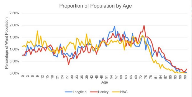
Age
Hartley and Hodsoll Street has the oldest age profile of anywhere in North Kent by some margin. 32.1% of people in Hartley are 65 and over, the only ward in north Kent to exceed 30%. This is a considerable rise since the last census when 27% of the population fell into this age group. New Ash Green has considerably greyed too with the proportion of their people over the age of 65 rising from 12.9% in 2011 to 22.2% in 2021.
The median age in Hartley is 52 years, for Longfield it is 50. New Ash Green is lower at 42. The most common ages at Hartley were 74 (118 people), and 72-73 (102 each)
Percentage of Population by Age Band compared with last census
| Hartley | New Ash Green | |||
| Age | 2011 | 2021 | 2011 | 2021 |
| Age 0 to 4 | 3.5 | 4.3 | 6.2 | 5.9 |
| Age 5 to 9 | 5.4 | 4.5 | 5.7 | 6.6 |
| Age 10 to 14 | 6 | 5 | 6.4 | 6.5 |
| Age 15 to 19 | 5.6 | 5.3 | 6.6 | 4.9 |
| Age 20 to 24 | 4.3 | 5 | 6.1 | 4.7 |
| Age 25 to 29 | 3.4 | 3 | 6.7 | 5.6 |
| Age 30 to 44 | 14 | 13.5 | 18.1 | 18.4 |
| Age 45 to 59 | 22.1 | 20.4 | 22.4 | 18.8 |
| Age 60 to 64 | 8.6 | 7 | 9 | 6.3 |
| Age 65 and over | 27.1 | 32.1 | 12.9 | 22.2 |
Sex
All three wards have around 52% population who is female. Given the older age profile, it is unsurprising that Hartley is the highest at 52.4%, this rises to 63.6% female in the Bramblefield Estate.
Marital Status
56.5% of Hartley and Hodsoll Street's adult population are married or civil partners, nearly all of opposite sex. 24.5% are single or co-habiting, 9.9% widowed and 9.1% divorced or separated.
When it comes to smaller areas, a lot of the differences can be put down the differing age profile. So Bramblefield has the highest rate of divorced (18.7%) and widowed (35.6%) and the lowest rate of single (never married) or cohabiting at 8.5%, while the younger area of Caxton Close has 43.3% single/cohabiting.
Migration
The local population is very stable. In Hartley 93.5% of the 2021 population were living there the year previously, with only slightly lower figures for Longfield (92.4%) and New Ash Green (92.2%). Most inward migration over the previous year was from within the UK. The people least likely to have moved over the previous year were from Cherry Trees and Carmelite Way, where 97.5% of the inhabitants had been there a year previously. The people most likely to have moved live in Springcroft and part of Gorsewood Road, but even then 90.4% had been living there a year before.
All three wards have similar levels of people born in the UK at around 93.5%. Less than 1% in all 3 wards have lived in the UK for less than 5 years. The highest numbers of those born abroad come from Europe, ranging from 2.3% (Hartley) to 2.9% (NAG), followed by Asia ranging from 1.2% (NAG) to 2.2% (Longfield).
Housing
Owner occupation has fallen slightly from 83.5% in 2011 to 81.7% in 2021. Although the aging population has meant that the numbers of people owning outright without a mortgage has risen. Owner occupation ranges from 33.9% in Caxton Close area to 97.8% in the Gorse Way area.
The biggest change is in private rented which rose since the last census from 4.8% to 8.1% of households.
Car Ownership
35% of households have 1 vehicles, 34% have 2 cars and 20% have 3 or more. One in ten households have no car, with the highest concentrations in Bramblefield (29%), Wellfield (18%), Brambledown and Caxton Close areas (15%). It seems a great shame that Arriva and Kent County Council have or plan to remove all buses serving Wellfield, where they are clearly most needed. As might be expected the more rural area of South Hartley is most likely to have a fleet of cars on the drive with 36% of households owning 3 or more vehicles.
Household Deprivation
53.6% of Longfield's households have none of the 4 dimensions of deprivation (that is education, health, housing and employment), with 53.3% for New Ash Green and 50.3% for Hartley. For Hartley the least deprived area is Fairby Lane / Chantry Avenue with 66.7% having no measures of deprivation. At the other end is Bramblefield, where only 26.6% of households have no measures of deprivation.
Passports
Nearly 90% of people in Longfield have passports, while the figure for Hartley and New Ash Green is around 87%. Some areas were significantly lower - Bramblefield (69.7%), Caxton Close/Porchester Close (70.3%), Brambledown/Pitfield (72.8%)
Ethnicity
93.7% of people in Hartley and Hodsoll Street said they were White, 3.3% Asian, 1.0% Black, and 1.4% Mixed. In New Ash Green, 95.4% were White, 1.2% each Asian and Black and 1.7% Mixed. For Longfield, the figures were 91.7% White, 4.4% Asian, 1.2% Black and 1.6% Mixed.
Identity
55% of the Hartley and Hodsoll Street ward identify as British only, 25.1% as English only, and 14.6% as English and British. Other UK and Irish identity made up 1.7%, while other identities (including other identities and a UK identity) were 3.7%. There were similar results for Longfield and New Ash Green wards.
Downs Valley and Old Downs area are most likely to think of themselves as British only (71.8%), at the opposite end the range were Brambledown/Pitfield (44.4% British only) and Bramblefield (44.7%). Bramblefield had the highest number of people saying they were English only (40.7%).
Religion
While nationally the number of people who are Christian has fallen below 50%, this is not the case in Hartley and Hodsoll Street, where 55.4% said they Christian. For the remainder the figures were No Religion (34.9%), Sikh (1.2%), Hindu (1.1%), Others (1.6%), Not answered (5.8%). Hartley seems to sit between Longfield (57.1% Christian) and New Ash Green (50.5% Christian). Within Hartley the range is from 40.6% Christian (Northfield, Culcroft, Hawthorns, Merton Ave) to 77.1% (Bramblefield)
Language
All adults in 97.6% of households in Hartley and Hodsoll Street have English as their main language (100% in Bramblefield). Conversely 0.9% of households have no English speakers or only children who can speak the language. There were similar numbers in New Ash Green and Longfield.
List of Output Areas for Hartley and Hodsoll Street Ward
Clearly they have tried to aggregate similar roads, but the need to have similar sized areas means that there are some odd shaped areas, in particular Stack Lane being put with parts of Woodland Avenue and Gorsewood Road.
| E00124068 | 191 | Hodsoll Street and Ridley |
| E00124069 | 117 | Church Road (to Dickens Close), Dickens Cl, Green Way |
| E00124070 | 133 | Gorse Way, Briars Way, Gorsewood Road SE |
| E00124071 | 141 | Stack Lane, Woodland Ave E, Gorsewood Road SW |
| E00124072 | 124 | Carmelite Way, Cherry Trees, The Warrens, St Johns Lane |
| E00124073 | 132 | Billings Hill Shaw, Manor Drive, Berrylands |
| E00124074 | 151 | South Hartley, Hartley Bottom Road |
| E00124075 | 170 | Bramblefield |
| E00124076 | 137 | Northfield, Culcroft, Hawthorns, Merton Ave |
| E00124077 | 138 | Hoselands Hill, Copse Side, Hottsfield, Banckside |
| E00124078 | 129 | Caxton Close, Porchester Close |
| E00124079 | 127 | Brambledown, Pitfield |
| E00124080 | 122 | Springcroft, Beechlands Close, Gorsewood Road N |
| E00124081 | 124 | Wellfield, Fortuna Cl, Merryfields, Silverdale, Hoselands View |
| E00124082 | 121 | Fairby Lane, Chantry Ave |
| E00124083 | 132 | Larksfield, Gresham Ave, Woodland Ave (W) |
| E00124084 | 127 | Downs Valley, Parkfield, Old Downs, Castle Hill, bordering Ash Road |
| E00124085 | 110 | Round Ash Way, Oast Way, Conifer Ave, Culvey Close |