Tithe Map 1848
Longfield > History
History of the Tithe
The Rector of Longfield had two main sources of income. The first was the land that went with the job called the Glebe land. In Longfield's case it was a few scattered fields. The most significant was the field that later became Langafel CofE Primary School. Behind it lies the Longfield Old Rectory, ironically this was historically in the parish of Hartley! The other (and more profitable) were the Tithes.
Tithes were an ancient 10% tax payable to the Church, on produce. In the 18th Century the legal author William Blackstone summarised this as:
..in general, tithes are to be paid for every thing that yields an annual increase, as corn, hay, fruit, cattle, poultry, and the like; but not for any thing that is of the substance of the earth, or is not of annual increase, as stone, lime, chalk, and the like; nor for creatures that are of a wild nature, or ferae naturae, as deer, hawks, &c, whose increase, so as to profit the owner, is not annual, but casual.....
No tax is very popular, but tithes were disliked for many reasons. It fell disproportionally on farm land. It also was objectionable to the many people who were of other denominations because it supported the Anglican Church, at this time non-conformists were particularly opposed. For historical reasons only 60% of the income from tithes nationally went to pay the parochial clergy, the people it was supposed to support. About 20% of the income from tithes was in the hands of laypeople (Parliamentary Report 1856). The agricultural slump of the 1930s led to great dissatisfaction. A Kentish vicar, Canon Brocklehurst said tithes were driving a wedge between the church and people. In his church near Ashford people refused to put anything in the collection plate and the road to the church was lined with placards saying it was a den of thieves not a house of prayer (Kent & Sussex Courier 1.3.1935).
Finally the Tithe Act 1936 abolished the rentcharge, replacing it with annuities payable to the government to last 60 years, unless redeemed or extinguished first. The annuities were less than the previous tithe rentcharge, charged at the rate of £91 11s 2d per £100 assessed tithe for farm land and £105 per £100 for other land. The tithe owners (the church) were compensated instead with government stock. This required tithe owners to submit details of what they received and new maps to be created. The latter were apparently done somewhat hastily. In the end the tithe annuities were abolished 20 years early in 1977, partly because the small sums weren't worth collecting.
For more information see National Archives - Tithes.
For more detail on how the tithe operated at Hartley see the Hartley Tithe page.
Tithe Map 1848
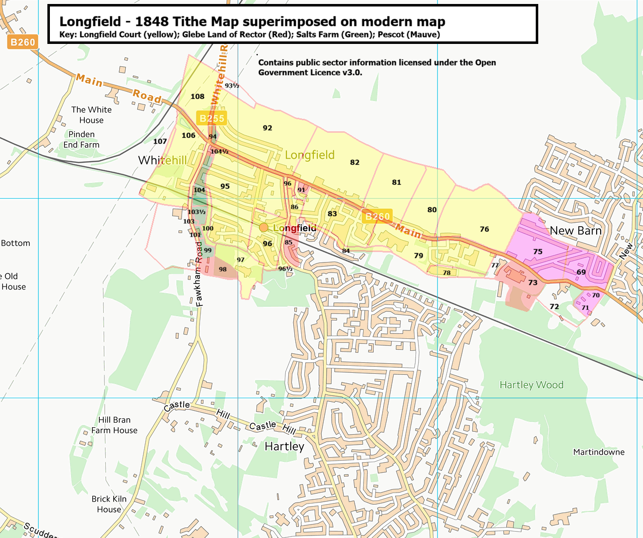
The following is a the tithe map produced under the Act superimposed on the modern OS map. The tithe map covered the whole parish of Longfield, so this is the extract for the village of Longfield.
The largest landowner was Longfield Court (yellow). There were three smaller farms - Salts Farm (green), Pescot (Mauve) and the Rector's glebe land (red). The field numbers are given (where they can be fitted in!) and listed in the accompanying schedule below.